You are here: Home > Network List > GS - US Geological Survey Networks Stations List
> Station KAN10 Keim Farm > Earthquake Result Viewer
KAN10 Keim Farm - Earthquake Result Viewer
| Earthquake location: |
Southern Alaska |
| Earthquake latitude/longitude: |
61.3/-149.9 |
| Earthquake time(UTC): |
2018/11/30 (334) 17:29:28 GMT |
| Earthquake Depth: |
43 km |
| Earthquake Magnitude: |
6.6 ml |
| Earthquake Catalog/Contributor: |
NEIC PDE/ak |
|
| Network: |
GS US Geological Survey Networks |
| Station: |
KAN10 Keim Farm |
| Lat/Lon: |
37.12 N/98.10 W |
| Elevation: |
417 m |
|
| Distance: |
40.1 deg |
| Az: |
102.81 deg |
| Baz: |
323.962 deg |
| Ray Param: |
0.07447832 |
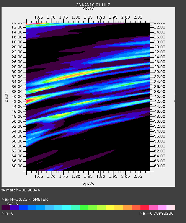
| Estimated Moho Depth: |
10.25 km |
| Estimated Crust Vp/Vs: |
1.60 |
| Assumed Crust Vp: |
6.426 km/s |
| Estimated Crust Vs: |
4.016 km/s |
| Estimated Crust Poisson's Ratio: |
0.18 |
|
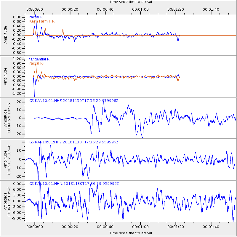
| Radial Match: |
80.90344 % |
| Radial Bump: |
400 |
| Transverse Match: |
95.93039 % |
| Transverse Bump: |
204 |
| SOD ConfigId: |
3165032 |
| Insert Time: |
2018-12-14 17:38:47.147 +0000 |
| GWidth: |
2.5 |
| Max Bumps: |
400 |
| Tol: |
0.001 |
|
Signal To Noise
| Channel | StoN | STA | LTA |
| GS:KAN10:01:HHZ:20181130T17:36:29.959996Z | 13.02703 | 1.0158885E-5 | 7.798313E-7 |
| GS:KAN10:01:HHN:20181130T17:36:29.959996Z | 6.2720704 | 4.9572127E-6 | 7.90363E-7 |
| GS:KAN10:01:HHE:20181130T17:36:29.959996Z | 12.5661545 | 9.589933E-6 | 7.6315575E-7 |
| Arrivals |
| Ps | 1.0 SECOND |
| PpPs | 3.8 SECOND |
| PsPs/PpSs | 4.9 SECOND |


