You are here: Home > Network List > GS - US Geological Survey Networks Stations List
> Station KAN13 Rinehart Farm > Earthquake Result Viewer
KAN13 Rinehart Farm - Earthquake Result Viewer
| Earthquake location: |
Southern Alaska |
| Earthquake latitude/longitude: |
61.3/-149.9 |
| Earthquake time(UTC): |
2018/11/30 (334) 17:29:28 GMT |
| Earthquake Depth: |
43 km |
| Earthquake Magnitude: |
6.6 ml |
| Earthquake Catalog/Contributor: |
NEIC PDE/ak |
|
| Network: |
GS US Geological Survey Networks |
| Station: |
KAN13 Rinehart Farm |
| Lat/Lon: |
37.01 N/97.48 W |
| Elevation: |
340 m |
|
| Distance: |
40.5 deg |
| Az: |
102.293 deg |
| Baz: |
323.939 deg |
| Ray Param: |
0.07426196 |
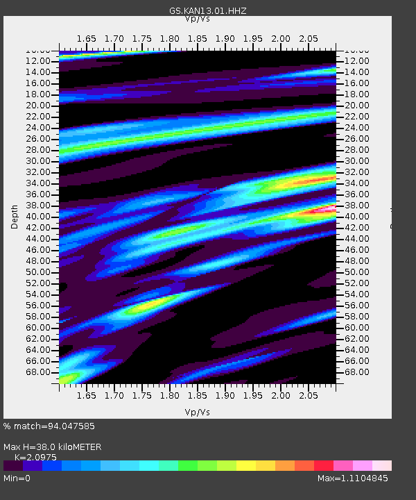
| Estimated Moho Depth: |
38.0 km |
| Estimated Crust Vp/Vs: |
2.10 |
| Assumed Crust Vp: |
6.483 km/s |
| Estimated Crust Vs: |
3.091 km/s |
| Estimated Crust Poisson's Ratio: |
0.35 |
|
| Radial Match: |
94.047585 % |
| Radial Bump: |
261 |
| Transverse Match: |
72.1739 % |
| Transverse Bump: |
400 |
| SOD ConfigId: |
3165032 |
| Insert Time: |
2018-12-14 17:38:50.241 +0000 |
| GWidth: |
2.5 |
| Max Bumps: |
400 |
| Tol: |
0.001 |
|
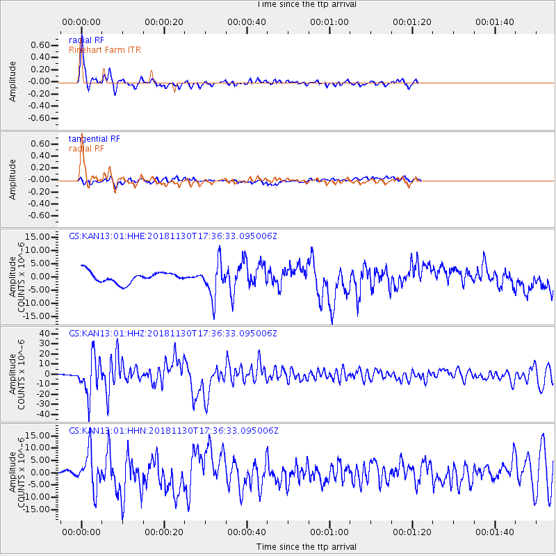
Signal To Noise
| Channel | StoN | STA | LTA |
| GS:KAN13:01:HHZ:20181130T17:36:33.095006Z | 22.195702 | 1.8706163E-5 | 8.427831E-7 |
| GS:KAN13:01:HHN:20181130T17:36:33.095006Z | 9.267135 | 7.858008E-6 | 8.479437E-7 |
| GS:KAN13:01:HHE:20181130T17:36:33.095006Z | 3.3036876 | 6.714621E-6 | 2.0324626E-6 |
| Arrivals |
| Ps | 6.8 SECOND |
| PpPs | 17 SECOND |
| PsPs/PpSs | 24 SECOND |


