You are here: Home > Network List > IW - Intermountain West Stations List
> Station MOOW Moose Ponds, Wyoming, USA > Earthquake Result Viewer
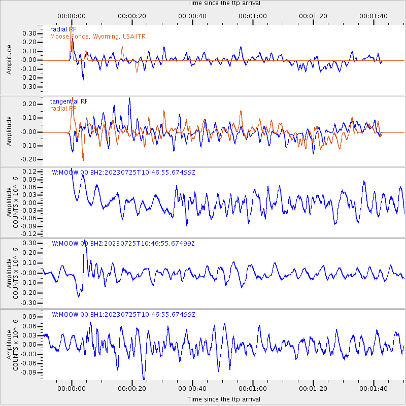
MOOW Moose Ponds, Wyoming, USA - Earthquake Result Viewer
*The percent match for this event was below the threshold and hence no stack was calculated.
| Earthquake location: |
Mariana Islands |
| Earthquake latitude/longitude: |
17.1/145.5 |
| Earthquake time(UTC): |
2023/07/25 (206) 10:35:18 GMT |
| Earthquake Depth: |
373 km |
| Earthquake Magnitude: |
5.6 mww |
| Earthquake Catalog/Contributor: |
NEIC PDE/us |
|
| Network: |
IW Intermountain West |
| Station: |
MOOW Moose Ponds, Wyoming, USA |
| Lat/Lon: |
43.75 N/110.74 W |
| Elevation: |
2128 m |
|
| Distance: |
87.9 deg |
| Az: |
44.782 deg |
| Baz: |
291.667 deg |
| Ray Param: |
$rayparam |
*The percent match for this event was below the threshold and hence was not used in the summary stack. |
|
| Radial Match: |
44.942333 % |
| Radial Bump: |
400 |
| Transverse Match: |
44.636833 % |
| Transverse Bump: |
400 |
| SOD ConfigId: |
30536071 |
| Insert Time: |
2023-08-08 10:54:50.056 +0000 |
| GWidth: |
2.5 |
| Max Bumps: |
400 |
| Tol: |
0.001 |
|
Signal To Noise
| Channel | StoN | STA | LTA |
| IW:MOOW:00:BHZ:20230725T10:46:55.67499Z | 3.9037738 | 1.6269577E-7 | 4.1676536E-8 |
| IW:MOOW:00:BH1:20230725T10:46:55.67499Z | 0.54867357 | 2.189801E-8 | 3.9910816E-8 |
| IW:MOOW:00:BH2:20230725T10:46:55.67499Z | 1.2158922 | 4.5063807E-8 | 3.706234E-8 |
| Arrivals |
| Ps | |
| PpPs | |
| PsPs/PpSs | |


