You are here: Home > Network List > GS - US Geological Survey Networks Stations List
> Station NE02 NE02 Southeast of Arnold, NE > Earthquake Result Viewer
NE02 NE02 Southeast of Arnold, NE - Earthquake Result Viewer
| Earthquake location: |
Southern Alaska |
| Earthquake latitude/longitude: |
61.3/-149.9 |
| Earthquake time(UTC): |
2018/11/30 (334) 17:29:28 GMT |
| Earthquake Depth: |
43 km |
| Earthquake Magnitude: |
6.6 ml |
| Earthquake Catalog/Contributor: |
NEIC PDE/ak |
|
| Network: |
GS US Geological Survey Networks |
| Station: |
NE02 NE02 Southeast of Arnold, NE |
| Lat/Lon: |
41.35 N/100.09 W |
| Elevation: |
817 m |
|
| Distance: |
35.8 deg |
| Az: |
100.628 deg |
| Baz: |
320.983 deg |
| Ray Param: |
0.076913826 |
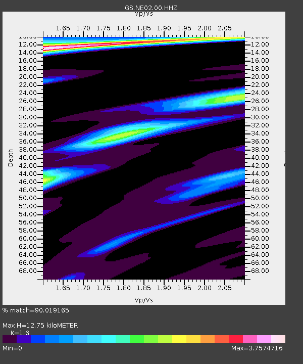
| Estimated Moho Depth: |
12.75 km |
| Estimated Crust Vp/Vs: |
1.60 |
| Assumed Crust Vp: |
6.483 km/s |
| Estimated Crust Vs: |
4.052 km/s |
| Estimated Crust Poisson's Ratio: |
0.18 |
|
| Radial Match: |
90.019165 % |
| Radial Bump: |
221 |
| Transverse Match: |
74.03032 % |
| Transverse Bump: |
333 |
| SOD ConfigId: |
3165032 |
| Insert Time: |
2018-12-14 17:38:57.045 +0000 |
| GWidth: |
2.5 |
| Max Bumps: |
400 |
| Tol: |
0.001 |
|

Signal To Noise
| Channel | StoN | STA | LTA |
| GS:NE02:00:HHZ:20181130T17:35:53.837987Z | 47.769627 | 2.3774037E-5 | 4.97681E-7 |
| GS:NE02:00:HH1:20181130T17:35:53.837987Z | 11.781357 | 1.4316512E-5 | 1.2151836E-6 |
| GS:NE02:00:HH2:20181130T17:35:53.837987Z | 13.865669 | 1.1995768E-5 | 8.651416E-7 |
| Arrivals |
| Ps | 1.3 SECOND |
| PpPs | 4.7 SECOND |
| PsPs/PpSs | 6.0 SECOND |


