You are here: Home > Network List > GS - US Geological Survey Networks Stations List
> Station OK029 Liberty Lake, Oklahoma, USA > Earthquake Result Viewer
OK029 Liberty Lake, Oklahoma, USA - Earthquake Result Viewer
| Earthquake location: |
Southern Alaska |
| Earthquake latitude/longitude: |
61.3/-149.9 |
| Earthquake time(UTC): |
2018/11/30 (334) 17:29:28 GMT |
| Earthquake Depth: |
43 km |
| Earthquake Magnitude: |
6.6 ml |
| Earthquake Catalog/Contributor: |
NEIC PDE/ak |
|
| Network: |
GS US Geological Survey Networks |
| Station: |
OK029 Liberty Lake, Oklahoma, USA |
| Lat/Lon: |
35.80 N/97.45 W |
| Elevation: |
333 m |
|
| Distance: |
41.5 deg |
| Az: |
103.348 deg |
| Baz: |
324.749 deg |
| Ray Param: |
0.07364508 |
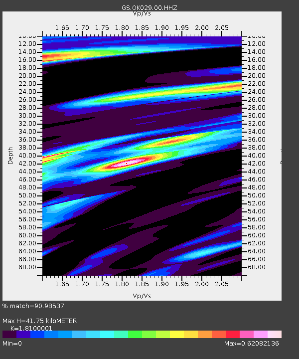
| Estimated Moho Depth: |
41.75 km |
| Estimated Crust Vp/Vs: |
1.81 |
| Assumed Crust Vp: |
6.426 km/s |
| Estimated Crust Vs: |
3.55 km/s |
| Estimated Crust Poisson's Ratio: |
0.28 |
|
| Radial Match: |
90.98537 % |
| Radial Bump: |
241 |
| Transverse Match: |
71.925835 % |
| Transverse Bump: |
396 |
| SOD ConfigId: |
3165032 |
| Insert Time: |
2018-12-14 17:38:59.993 +0000 |
| GWidth: |
2.5 |
| Max Bumps: |
400 |
| Tol: |
0.001 |
|

Signal To Noise
| Channel | StoN | STA | LTA |
| GS:OK029:00:HHZ:20181130T17:36:41.290013Z | 29.059523 | 1.4746711E-5 | 5.074657E-7 |
| GS:OK029:00:HH1:20181130T17:36:41.290013Z | 9.639109 | 5.857487E-6 | 6.0767934E-7 |
| GS:OK029:00:HH2:20181130T17:36:41.290013Z | 8.167599 | 5.2982377E-6 | 6.4868976E-7 |
| Arrivals |
| Ps | 5.6 SECOND |
| PpPs | 17 SECOND |
| PsPs/PpSs | 23 SECOND |


