You are here: Home > Network List > GS - US Geological Survey Networks Stations List
> Station OK052 Battle Ridge Rd, NW of Cushing, OK, USA > Earthquake Result Viewer
OK052 Battle Ridge Rd, NW of Cushing, OK, USA - Earthquake Result Viewer
| Earthquake location: |
Southern Alaska |
| Earthquake latitude/longitude: |
61.3/-149.9 |
| Earthquake time(UTC): |
2018/11/30 (334) 17:29:28 GMT |
| Earthquake Depth: |
43 km |
| Earthquake Magnitude: |
6.6 ml |
| Earthquake Catalog/Contributor: |
NEIC PDE/ak |
|
| Network: |
GS US Geological Survey Networks |
| Station: |
OK052 Battle Ridge Rd, NW of Cushing, OK, USA |
| Lat/Lon: |
35.99 N/96.80 W |
| Elevation: |
259 m |
|
| Distance: |
41.6 deg |
| Az: |
102.526 deg |
| Baz: |
324.515 deg |
| Ray Param: |
0.0735516 |
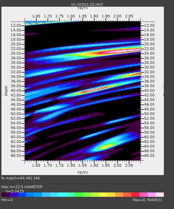
| Estimated Moho Depth: |
22.5 km |
| Estimated Crust Vp/Vs: |
2.04 |
| Assumed Crust Vp: |
6.426 km/s |
| Estimated Crust Vs: |
3.146 km/s |
| Estimated Crust Poisson's Ratio: |
0.34 |
|
| Radial Match: |
94.481346 % |
| Radial Bump: |
326 |
| Transverse Match: |
73.37098 % |
| Transverse Bump: |
400 |
| SOD ConfigId: |
3165032 |
| Insert Time: |
2018-12-14 17:39:07.476 +0000 |
| GWidth: |
2.5 |
| Max Bumps: |
400 |
| Tol: |
0.001 |
|

Signal To Noise
| Channel | StoN | STA | LTA |
| GS:OK052:00:HHZ:20181130T17:36:42.479985Z | 18.96009 | 1.27164785E-5 | 6.7069715E-7 |
| GS:OK052:00:HH1:20181130T17:36:42.479985Z | 9.731481 | 6.0239117E-6 | 6.190129E-7 |
| GS:OK052:00:HH2:20181130T17:36:42.479985Z | 11.900274 | 5.609547E-6 | 4.7137965E-7 |
| Arrivals |
| Ps | 3.9 SECOND |
| PpPs | 10 SECOND |
| PsPs/PpSs | 14 SECOND |


