You are here: Home > Network List > II - Global Seismograph Network (GSN - IRIS/IDA) Stations List
> Station CMLA Cha de Macela, Sao Miguel Island, Azores > Earthquake Result Viewer
CMLA Cha de Macela, Sao Miguel Island, Azores - Earthquake Result Viewer
| Earthquake location: |
Southern Alaska |
| Earthquake latitude/longitude: |
61.3/-149.9 |
| Earthquake time(UTC): |
2018/11/30 (334) 17:29:28 GMT |
| Earthquake Depth: |
43 km |
| Earthquake Magnitude: |
6.6 ml |
| Earthquake Catalog/Contributor: |
NEIC PDE/ak |
|
| Network: |
II Global Seismograph Network (GSN - IRIS/IDA) |
| Station: |
CMLA Cha de Macela, Sao Miguel Island, Azores |
| Lat/Lon: |
37.76 N/25.52 W |
| Elevation: |
429 m |
|
| Distance: |
71.4 deg |
| Az: |
43.611 deg |
| Baz: |
335.184 deg |
| Ray Param: |
0.054249436 |
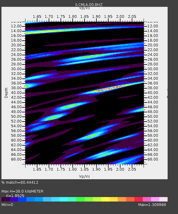
| Estimated Moho Depth: |
38.0 km |
| Estimated Crust Vp/Vs: |
1.95 |
| Assumed Crust Vp: |
4.802 km/s |
| Estimated Crust Vs: |
2.459 km/s |
| Estimated Crust Poisson's Ratio: |
0.32 |
|
| Radial Match: |
80.44412 % |
| Radial Bump: |
400 |
| Transverse Match: |
78.38075 % |
| Transverse Bump: |
398 |
| SOD ConfigId: |
3165032 |
| Insert Time: |
2018-12-14 17:39:21.159 +0000 |
| GWidth: |
2.5 |
| Max Bumps: |
400 |
| Tol: |
0.001 |
|

Signal To Noise
| Channel | StoN | STA | LTA |
| II:CMLA:00:BHZ:20181130T17:40:13.818975Z | 10.090587 | 2.197158E-5 | 2.1774333E-6 |
| II:CMLA:00:BH1:20181130T17:40:13.818975Z | 1.7819676 | 7.6169204E-6 | 4.2744437E-6 |
| II:CMLA:00:BH2:20181130T17:40:13.818975Z | 2.0815082 | 3.892419E-6 | 1.8699994E-6 |
| Arrivals |
| Ps | 7.7 SECOND |
| PpPs | 23 SECOND |
| PsPs/PpSs | 31 SECOND |


