You are here: Home > Network List > IW - Intermountain West Stations List
> Station MOOW Moose Ponds, Wyoming, USA > Earthquake Result Viewer
MOOW Moose Ponds, Wyoming, USA - Earthquake Result Viewer
*The percent match for this event was below the threshold and hence no stack was calculated.
| Earthquake location: |
Near Coast Of Central Chile |
| Earthquake latitude/longitude: |
-37.8/-73.3 |
| Earthquake time(UTC): |
2010/06/29 (180) 01:40:00 GMT |
| Earthquake Depth: |
17 km |
| Earthquake Magnitude: |
6.0 MB, 5.2 MS, 5.5 MW, 6.1 ML |
| Earthquake Catalog/Contributor: |
WHDF/NEIC |
|
| Network: |
IW Intermountain West |
| Station: |
MOOW Moose Ponds, Wyoming, USA |
| Lat/Lon: |
43.75 N/110.74 W |
| Elevation: |
2128 m |
|
| Distance: |
88.0 deg |
| Az: |
333.826 deg |
| Baz: |
151.189 deg |
| Ray Param: |
$rayparam |
*The percent match for this event was below the threshold and hence was not used in the summary stack. |
|
| Radial Match: |
64.895805 % |
| Radial Bump: |
400 |
| Transverse Match: |
65.459496 % |
| Transverse Bump: |
400 |
| SOD ConfigId: |
318645 |
| Insert Time: |
2010-11-29 20:01:41.275 +0000 |
| GWidth: |
2.5 |
| Max Bumps: |
400 |
| Tol: |
0.001 |
|
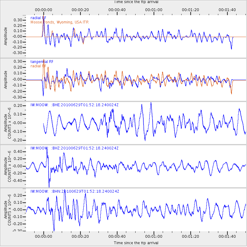
Signal To Noise
| Channel | StoN | STA | LTA |
| IW:MOOW: :BHZ:20100629T01:52:18.240024Z | 2.7267137 | 2.3617446E-7 | 8.661505E-8 |
| IW:MOOW: :BHN:20100629T01:52:18.240024Z | 2.3905845 | 7.078629E-8 | 2.9610455E-8 |
| IW:MOOW: :BHE:20100629T01:52:18.240024Z | 0.9545676 | 6.45236E-8 | 6.759458E-8 |
| Arrivals |
| Ps | |
| PpPs | |
| PsPs/PpSs | |


