You are here: Home > Network List > TA - USArray Transportable Network (new EarthScope stations) Stations List
> Station T33A Patterson Ranch, Waldron, KS, USA > Earthquake Result Viewer
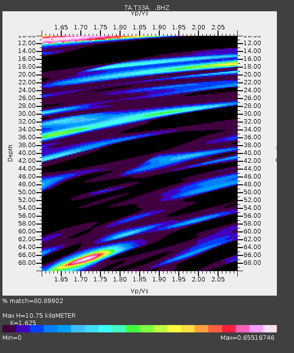
T33A Patterson Ranch, Waldron, KS, USA - Earthquake Result Viewer
| Earthquake location: |
Near Coast Of Central Chile |
| Earthquake latitude/longitude: |
-37.8/-73.3 |
| Earthquake time(UTC): |
2010/06/29 (180) 01:40:00 GMT |
| Earthquake Depth: |
17 km |
| Earthquake Magnitude: |
6.0 MB, 5.2 MS, 5.5 MW, 6.1 ML |
| Earthquake Catalog/Contributor: |
WHDF/NEIC |
|
| Network: |
TA USArray Transportable Network (new EarthScope stations) |
| Station: |
T33A Patterson Ranch, Waldron, KS, USA |
| Lat/Lon: |
37.08 N/98.24 W |
| Elevation: |
394 m |
|
| Distance: |
78.0 deg |
| Az: |
339.816 deg |
| Baz: |
160.025 deg |
| Ray Param: |
0.04990155 |
| Estimated Moho Depth: |
10.75 km |
| Estimated Crust Vp/Vs: |
1.62 |
| Assumed Crust Vp: |
6.426 km/s |
| Estimated Crust Vs: |
3.955 km/s |
| Estimated Crust Poisson's Ratio: |
0.20 |
|
| Radial Match: |
80.89902 % |
| Radial Bump: |
400 |
| Transverse Match: |
69.869225 % |
| Transverse Bump: |
400 |
| SOD ConfigId: |
318645 |
| Insert Time: |
2010-11-29 20:04:14.479 +0000 |
| GWidth: |
2.5 |
| Max Bumps: |
400 |
| Tol: |
0.001 |
|

Signal To Noise
| Channel | StoN | STA | LTA |
| TA:T33A: :BHZ:20100629T01:51:26.800022Z | 15.432843 | 1.8381543E-6 | 1.1910665E-7 |
| TA:T33A: :BHN:20100629T01:51:26.800022Z | 4.9927397 | 5.44593E-7 | 1.09076986E-7 |
| TA:T33A: :BHE:20100629T01:51:26.800022Z | 2.6633208 | 3.048971E-7 | 1.1448006E-7 |
| Arrivals |
| Ps | 1.1 SECOND |
| PpPs | 4.2 SECOND |
| PsPs/PpSs | 5.3 SECOND |


