You are here: Home > Network List > IU - Global Seismograph Network (GSN - IRIS/USGS) Stations List
> Station SFJD Sondre Stromfjord, Greenland > Earthquake Result Viewer
SFJD Sondre Stromfjord, Greenland - Earthquake Result Viewer
| Earthquake location: |
Southern Alaska |
| Earthquake latitude/longitude: |
61.3/-149.9 |
| Earthquake time(UTC): |
2018/11/30 (334) 17:29:28 GMT |
| Earthquake Depth: |
43 km |
| Earthquake Magnitude: |
6.6 ml |
| Earthquake Catalog/Contributor: |
NEIC PDE/ak |
|
| Network: |
IU Global Seismograph Network (GSN - IRIS/USGS) |
| Station: |
SFJD Sondre Stromfjord, Greenland |
| Lat/Lon: |
67.00 N/50.62 W |
| Elevation: |
330 m |
|
| Distance: |
39.2 deg |
| Az: |
37.849 deg |
| Baz: |
311.161 deg |
| Ray Param: |
0.07501863 |
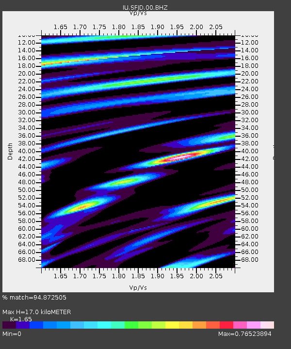
| Estimated Moho Depth: |
17.0 km |
| Estimated Crust Vp/Vs: |
1.65 |
| Assumed Crust Vp: |
6.459 km/s |
| Estimated Crust Vs: |
3.915 km/s |
| Estimated Crust Poisson's Ratio: |
0.21 |
|
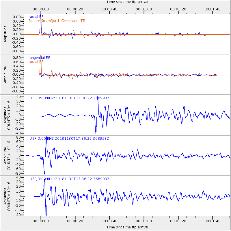
| Radial Match: |
94.872505 % |
| Radial Bump: |
251 |
| Transverse Match: |
84.76151 % |
| Transverse Bump: |
393 |
| SOD ConfigId: |
3165032 |
| Insert Time: |
2018-12-14 17:40:04.935 +0000 |
| GWidth: |
2.5 |
| Max Bumps: |
400 |
| Tol: |
0.001 |
|
Signal To Noise
| Channel | StoN | STA | LTA |
| IU:SFJD:00:BHZ:20181130T17:36:22.368993Z | 18.917234 | 3.7313755E-5 | 1.9724741E-6 |
| IU:SFJD:00:BH1:20181130T17:36:22.368993Z | 26.6887 | 1.7273673E-5 | 6.47228E-7 |
| IU:SFJD:00:BH2:20181130T17:36:22.368993Z | 11.085056 | 1.7952252E-5 | 1.6195004E-6 |
| Arrivals |
| Ps | 1.8 SECOND |
| PpPs | 6.5 SECOND |
| PsPs/PpSs | 8.3 SECOND |


