You are here: Home > Network List > AK - Alaska Regional Network Stations List
> Station M11K Mekoryuk, AK, USA > Earthquake Result Viewer
M11K Mekoryuk, AK, USA - Earthquake Result Viewer
| Earthquake location: |
Vanuatu Islands |
| Earthquake latitude/longitude: |
-14.8/167.9 |
| Earthquake time(UTC): |
2023/07/26 (207) 12:44:35 GMT |
| Earthquake Depth: |
13 km |
| Earthquake Magnitude: |
6.4 mww |
| Earthquake Catalog/Contributor: |
NEIC PDE/us |
|
| Network: |
AK Alaska Regional Network |
| Station: |
M11K Mekoryuk, AK, USA |
| Lat/Lon: |
60.38 N/166.20 W |
| Elevation: |
3.0 m |
|
| Distance: |
77.7 deg |
| Az: |
12.819 deg |
| Baz: |
205.604 deg |
| Ray Param: |
0.05013459 |
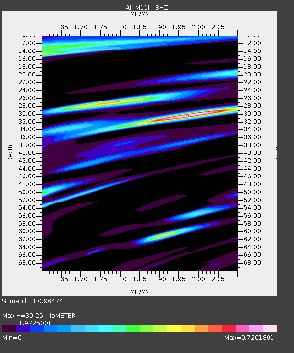
| Estimated Moho Depth: |
30.25 km |
| Estimated Crust Vp/Vs: |
1.97 |
| Assumed Crust Vp: |
6.134 km/s |
| Estimated Crust Vs: |
3.11 km/s |
| Estimated Crust Poisson's Ratio: |
0.33 |
|
| Radial Match: |
80.96474 % |
| Radial Bump: |
400 |
| Transverse Match: |
62.96482 % |
| Transverse Bump: |
400 |
| SOD ConfigId: |
31937991 |
| Insert Time: |
2023-08-09 12:48:50.911 +0000 |
| GWidth: |
2.5 |
| Max Bumps: |
400 |
| Tol: |
0.001 |
|

Signal To Noise
| Channel | StoN | STA | LTA |
| AK:M11K: :BHZ:20230726T12:56:00.720021Z | 5.551648 | 1.6286732E-6 | 2.9336752E-7 |
| AK:M11K: :BHN:20230726T12:56:00.720021Z | 2.7553356 | 6.249376E-7 | 2.2680999E-7 |
| AK:M11K: :BHE:20230726T12:56:00.720021Z | 2.0682995 | 5.4668436E-7 | 2.6431584E-7 |
| Arrivals |
| Ps | 4.9 SECOND |
| PpPs | 14 SECOND |
| PsPs/PpSs | 19 SECOND |


