You are here: Home > Network List > AK - Alaska Regional Network Stations List
> Station P23K Montague Island, AK, USA > Earthquake Result Viewer
P23K Montague Island, AK, USA - Earthquake Result Viewer
| Earthquake location: |
Vanuatu Islands |
| Earthquake latitude/longitude: |
-14.8/167.9 |
| Earthquake time(UTC): |
2023/07/26 (207) 12:44:35 GMT |
| Earthquake Depth: |
13 km |
| Earthquake Magnitude: |
6.4 mww |
| Earthquake Catalog/Contributor: |
NEIC PDE/us |
|
| Network: |
AK Alaska Regional Network |
| Station: |
P23K Montague Island, AK, USA |
| Lat/Lon: |
60.00 N/147.40 W |
| Elevation: |
287 m |
|
| Distance: |
82.7 deg |
| Az: |
20.869 deg |
| Baz: |
223.296 deg |
| Ray Param: |
0.046698876 |
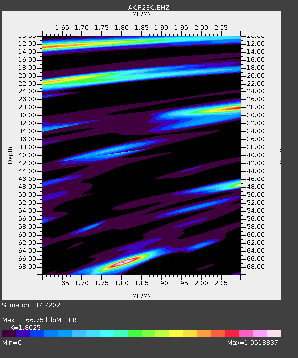
| Estimated Moho Depth: |
66.75 km |
| Estimated Crust Vp/Vs: |
1.80 |
| Assumed Crust Vp: |
5.989 km/s |
| Estimated Crust Vs: |
3.323 km/s |
| Estimated Crust Poisson's Ratio: |
0.28 |
|
| Radial Match: |
87.72021 % |
| Radial Bump: |
400 |
| Transverse Match: |
82.64327 % |
| Transverse Bump: |
400 |
| SOD ConfigId: |
31937991 |
| Insert Time: |
2023-08-09 12:49:24.194 +0000 |
| GWidth: |
2.5 |
| Max Bumps: |
400 |
| Tol: |
0.001 |
|

Signal To Noise
| Channel | StoN | STA | LTA |
| AK:P23K: :BHZ:20230726T12:56:27.499989Z | 13.547608 | 2.1386036E-6 | 1.5785838E-7 |
| AK:P23K: :BHN:20230726T12:56:27.499989Z | 3.7875552 | 5.1564774E-7 | 1.3614263E-7 |
| AK:P23K: :BHE:20230726T12:56:27.499989Z | 1.6765727 | 2.8110168E-7 | 1.6766448E-7 |
| Arrivals |
| Ps | 9.1 SECOND |
| PpPs | 31 SECOND |
| PsPs/PpSs | 40 SECOND |


