You are here: Home > Network List > AV - Alaska Volcano Observatory Stations List
> Station AMKA Regional Station, Amchitka Island, Alaska > Earthquake Result Viewer
AMKA Regional Station, Amchitka Island, Alaska - Earthquake Result Viewer
| Earthquake location: |
Vanuatu Islands |
| Earthquake latitude/longitude: |
-14.8/167.9 |
| Earthquake time(UTC): |
2023/07/26 (207) 12:44:35 GMT |
| Earthquake Depth: |
13 km |
| Earthquake Magnitude: |
6.4 mww |
| Earthquake Catalog/Contributor: |
NEIC PDE/us |
|
| Network: |
AV Alaska Volcano Observatory |
| Station: |
AMKA Regional Station, Amchitka Island, Alaska |
| Lat/Lon: |
51.38 N/179.30 E |
| Elevation: |
116 m |
|
| Distance: |
66.6 deg |
| Az: |
7.746 deg |
| Baz: |
192.008 deg |
| Ray Param: |
0.05750743 |
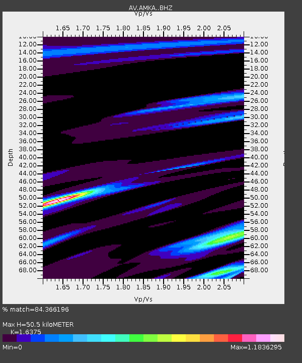
| Estimated Moho Depth: |
50.5 km |
| Estimated Crust Vp/Vs: |
1.64 |
| Assumed Crust Vp: |
6.183 km/s |
| Estimated Crust Vs: |
3.776 km/s |
| Estimated Crust Poisson's Ratio: |
0.20 |
|
| Radial Match: |
84.366196 % |
| Radial Bump: |
400 |
| Transverse Match: |
75.292496 % |
| Transverse Bump: |
400 |
| SOD ConfigId: |
31937991 |
| Insert Time: |
2023-08-09 12:52:03.969 +0000 |
| GWidth: |
2.5 |
| Max Bumps: |
400 |
| Tol: |
0.001 |
|

Signal To Noise
| Channel | StoN | STA | LTA |
| AV:AMKA: :BHZ:20230726T12:54:54.358998Z | 5.04432 | 1.0752059E-6 | 2.131518E-7 |
| AV:AMKA: :BHN:20230726T12:54:54.358998Z | 2.469691 | 4.3758715E-7 | 1.7718294E-7 |
| AV:AMKA: :BHE:20230726T12:54:54.358998Z | 2.388479 | 3.610176E-7 | 1.5114958E-7 |
| Arrivals |
| Ps | 5.4 SECOND |
| PpPs | 21 SECOND |
| PsPs/PpSs | 26 SECOND |


