You are here: Home > Network List > TA - USArray Transportable Network (new EarthScope stations) Stations List
> Station 339A Huntington, TX, USA > Earthquake Result Viewer
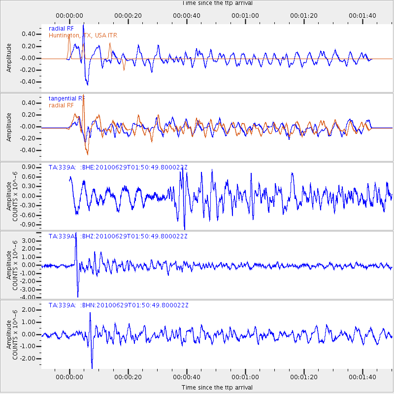
339A Huntington, TX, USA - Earthquake Result Viewer
*The percent match for this event was below the threshold and hence no stack was calculated.
| Earthquake location: |
Near Coast Of Central Chile |
| Earthquake latitude/longitude: |
-37.8/-73.3 |
| Earthquake time(UTC): |
2010/06/29 (180) 01:40:00 GMT |
| Earthquake Depth: |
17 km |
| Earthquake Magnitude: |
6.0 MB, 5.2 MS, 5.5 MW, 6.1 ML |
| Earthquake Catalog/Contributor: |
WHDF/NEIC |
|
| Network: |
TA USArray Transportable Network (new EarthScope stations) |
| Station: |
339A Huntington, TX, USA |
| Lat/Lon: |
31.33 N/94.56 W |
| Elevation: |
82 m |
|
| Distance: |
71.6 deg |
| Az: |
340.9 deg |
| Baz: |
162.376 deg |
| Ray Param: |
$rayparam |
*The percent match for this event was below the threshold and hence was not used in the summary stack. |
|
| Radial Match: |
72.30277 % |
| Radial Bump: |
400 |
| Transverse Match: |
58.445145 % |
| Transverse Bump: |
400 |
| SOD ConfigId: |
318645 |
| Insert Time: |
2010-11-29 20:09:42.744 +0000 |
| GWidth: |
2.5 |
| Max Bumps: |
400 |
| Tol: |
0.001 |
|
Signal To Noise
| Channel | StoN | STA | LTA |
| TA:339A: :BHZ:20100629T01:50:49.800022Z | 13.121323 | 1.4298954E-6 | 1.0897494E-7 |
| TA:339A: :BHN:20100629T01:50:49.800022Z | 0.60942143 | 1.6907035E-7 | 2.7742763E-7 |
| TA:339A: :BHE:20100629T01:50:49.800022Z | 0.40294853 | 1.04804776E-7 | 2.6009468E-7 |
| Arrivals |
| Ps | |
| PpPs | |
| PsPs/PpSs | |


