You are here: Home > Network List > AV - Alaska Volcano Observatory Stations List
> Station SPNN North Nagishlamina, Mount Spurr, Alaska > Earthquake Result Viewer
SPNN North Nagishlamina, Mount Spurr, Alaska - Earthquake Result Viewer
| Earthquake location: |
Vanuatu Islands |
| Earthquake latitude/longitude: |
-14.8/167.9 |
| Earthquake time(UTC): |
2023/07/26 (207) 12:44:35 GMT |
| Earthquake Depth: |
13 km |
| Earthquake Magnitude: |
6.4 mww |
| Earthquake Catalog/Contributor: |
NEIC PDE/us |
|
| Network: |
AV Alaska Volcano Observatory |
| Station: |
SPNN North Nagishlamina, Mount Spurr, Alaska |
| Lat/Lon: |
61.37 N/152.70 W |
| Elevation: |
1666 m |
|
| Distance: |
82.0 deg |
| Az: |
17.974 deg |
| Baz: |
218.298 deg |
| Ray Param: |
0.047155432 |
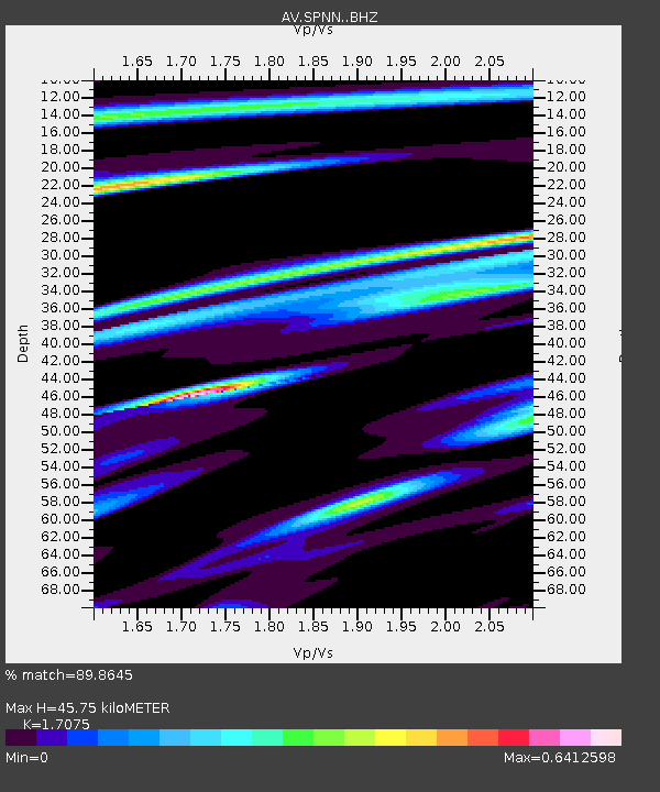
| Estimated Moho Depth: |
45.75 km |
| Estimated Crust Vp/Vs: |
1.71 |
| Assumed Crust Vp: |
6.566 km/s |
| Estimated Crust Vs: |
3.845 km/s |
| Estimated Crust Poisson's Ratio: |
0.24 |
|
| Radial Match: |
89.8645 % |
| Radial Bump: |
400 |
| Transverse Match: |
85.29074 % |
| Transverse Bump: |
400 |
| SOD ConfigId: |
31937991 |
| Insert Time: |
2023-08-09 12:55:15.643 +0000 |
| GWidth: |
2.5 |
| Max Bumps: |
400 |
| Tol: |
0.001 |
|

Signal To Noise
| Channel | StoN | STA | LTA |
| AV:SPNN: :BHZ:20230726T12:56:24.040028Z | 24.918009 | 1.4264068E-6 | 5.7244012E-8 |
| AV:SPNN: :BHN:20230726T12:56:24.040028Z | 6.504811 | 3.3764687E-7 | 5.190725E-8 |
| AV:SPNN: :BHE:20230726T12:56:24.040028Z | 9.577555 | 4.497796E-7 | 4.696184E-8 |
| Arrivals |
| Ps | 5.1 SECOND |
| PpPs | 18 SECOND |
| PsPs/PpSs | 23 SECOND |


