You are here: Home > Network List > NM - Cooperative New Madrid Seismic Network Stations List
> Station X502 Temporary Arkansas > Earthquake Result Viewer
X502 Temporary Arkansas - Earthquake Result Viewer
| Earthquake location: |
Southern Alaska |
| Earthquake latitude/longitude: |
61.3/-149.9 |
| Earthquake time(UTC): |
2018/11/30 (334) 17:29:28 GMT |
| Earthquake Depth: |
43 km |
| Earthquake Magnitude: |
6.6 ml |
| Earthquake Catalog/Contributor: |
NEIC PDE/ak |
|
| Network: |
NM Cooperative New Madrid Seismic Network |
| Station: |
X502 Temporary Arkansas |
| Lat/Lon: |
35.49 N/92.39 W |
| Elevation: |
344 m |
|
| Distance: |
44.1 deg |
| Az: |
98.666 deg |
| Baz: |
324.254 deg |
| Ray Param: |
0.071993254 |
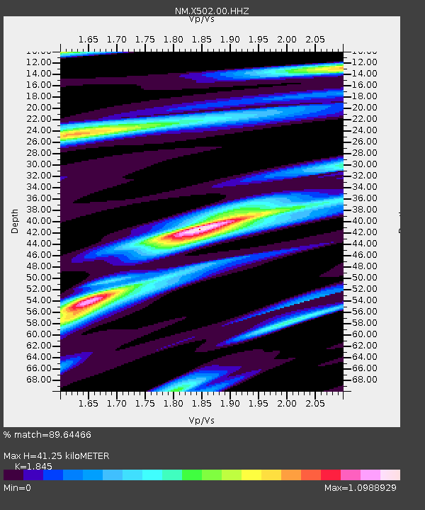
| Estimated Moho Depth: |
41.25 km |
| Estimated Crust Vp/Vs: |
1.85 |
| Assumed Crust Vp: |
6.498 km/s |
| Estimated Crust Vs: |
3.522 km/s |
| Estimated Crust Poisson's Ratio: |
0.29 |
|
| Radial Match: |
89.64466 % |
| Radial Bump: |
348 |
| Transverse Match: |
69.85855 % |
| Transverse Bump: |
400 |
| SOD ConfigId: |
3165032 |
| Insert Time: |
2018-12-14 17:41:24.818 +0000 |
| GWidth: |
2.5 |
| Max Bumps: |
400 |
| Tol: |
0.001 |
|

Signal To Noise
| Channel | StoN | STA | LTA |
| NM:X502:00:HHZ:20181130T17:37:02.690007Z | 21.714903 | 1.2760286E-5 | 5.8762805E-7 |
| NM:X502:00:HHN:20181130T17:37:02.690007Z | 10.385536 | 7.285511E-6 | 7.0150554E-7 |
| NM:X502:00:HHE:20181130T17:37:02.690007Z | 8.41152 | 5.028173E-6 | 5.977722E-7 |
| Arrivals |
| Ps | 5.7 SECOND |
| PpPs | 17 SECOND |
| PsPs/PpSs | 23 SECOND |


