You are here: Home > Network List > NO - Norwegian Seismic Array Network Stations List
> Station SPB3 > Earthquake Result Viewer
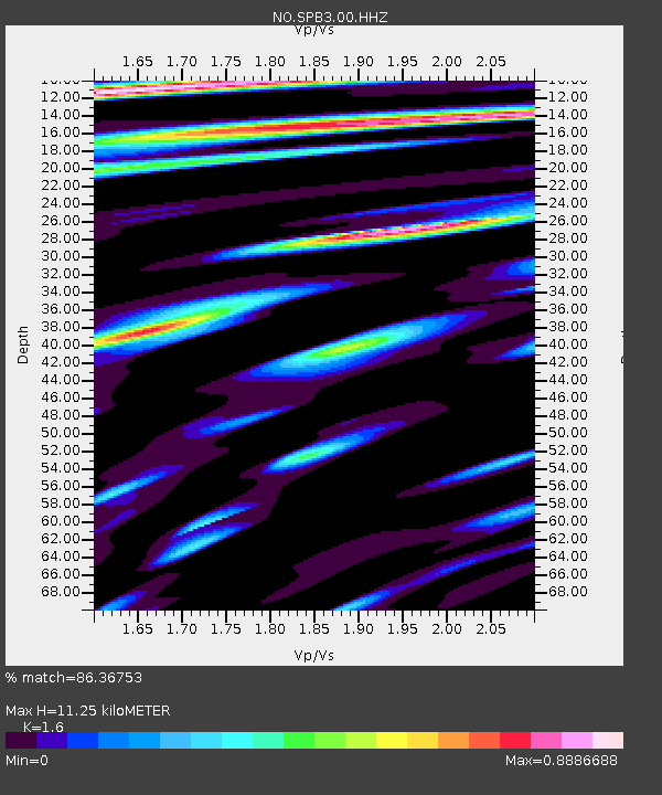
SPB3 - Earthquake Result Viewer
| Earthquake location: |
Southern Alaska |
| Earthquake latitude/longitude: |
61.3/-149.9 |
| Earthquake time(UTC): |
2018/11/30 (334) 17:29:28 GMT |
| Earthquake Depth: |
43 km |
| Earthquake Magnitude: |
6.6 ml |
| Earthquake Catalog/Contributor: |
NEIC PDE/ak |
|
| Network: |
NO Norwegian Seismic Array Network |
| Station: |
SPB3 |
| Lat/Lon: |
78.17 N/16.36 E |
| Elevation: |
234 m |
|
| Distance: |
40.5 deg |
| Az: |
4.319 deg |
| Baz: |
349.859 deg |
| Ray Param: |
0.0742734 |
| Estimated Moho Depth: |
11.25 km |
| Estimated Crust Vp/Vs: |
1.60 |
| Assumed Crust Vp: |
6.545 km/s |
| Estimated Crust Vs: |
4.091 km/s |
| Estimated Crust Poisson's Ratio: |
0.18 |
|
| Radial Match: |
86.36753 % |
| Radial Bump: |
400 |
| Transverse Match: |
79.93705 % |
| Transverse Bump: |
400 |
| SOD ConfigId: |
3165032 |
| Insert Time: |
2018-12-14 17:41:31.981 +0000 |
| GWidth: |
2.5 |
| Max Bumps: |
400 |
| Tol: |
0.001 |
|

Signal To Noise
| Channel | StoN | STA | LTA |
| NO:SPB3:00:HHZ:20181130T17:36:32.936986Z | 15.171477 | 5.074536E-6 | 3.344787E-7 |
| NO:SPB3:00:HHN:20181130T17:36:32.936986Z | 13.920889 | 3.1660202E-6 | 2.2742945E-7 |
| NO:SPB3:00:HHE:20181130T17:36:32.936986Z | 3.5666013 | 1.112719E-6 | 3.11983E-7 |
| Arrivals |
| Ps | 1.1 SECOND |
| PpPs | 4.1 SECOND |
| PsPs/PpSs | 5.2 SECOND |


