You are here: Home > Network List > CI - Caltech Regional Seismic Network Stations List
> Station BFS Mt Baldy Forest Station > Earthquake Result Viewer
BFS Mt Baldy Forest Station - Earthquake Result Viewer
| Earthquake location: |
Vanuatu Islands |
| Earthquake latitude/longitude: |
-14.8/167.9 |
| Earthquake time(UTC): |
2023/07/26 (207) 12:44:35 GMT |
| Earthquake Depth: |
13 km |
| Earthquake Magnitude: |
6.4 mww |
| Earthquake Catalog/Contributor: |
NEIC PDE/us |
|
| Network: |
CI Caltech Regional Seismic Network |
| Station: |
BFS Mt Baldy Forest Station |
| Lat/Lon: |
34.24 N/117.66 W |
| Elevation: |
1312 m |
|
| Distance: |
85.8 deg |
| Az: |
53.147 deg |
| Baz: |
249.136 deg |
| Ray Param: |
0.044509895 |
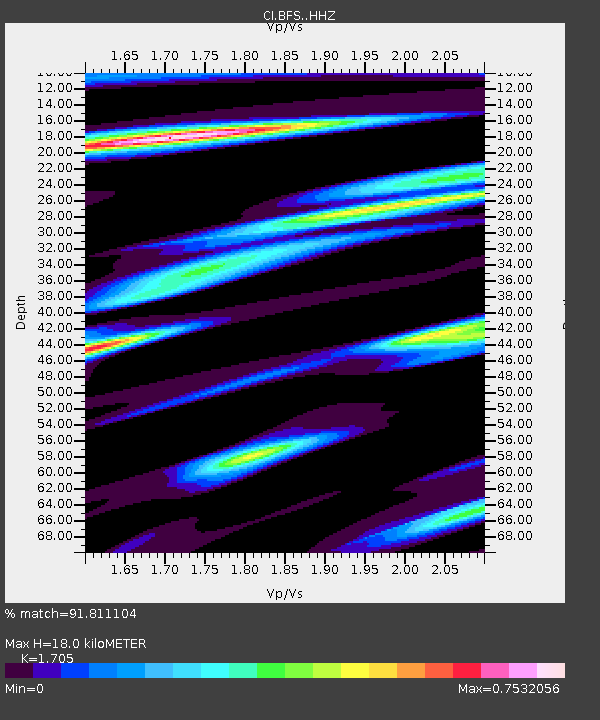
| Estimated Moho Depth: |
18.0 km |
| Estimated Crust Vp/Vs: |
1.71 |
| Assumed Crust Vp: |
6.276 km/s |
| Estimated Crust Vs: |
3.681 km/s |
| Estimated Crust Poisson's Ratio: |
0.24 |
|
| Radial Match: |
91.811104 % |
| Radial Bump: |
400 |
| Transverse Match: |
89.41108 % |
| Transverse Bump: |
400 |
| SOD ConfigId: |
31937991 |
| Insert Time: |
2023-08-09 12:59:10.053 +0000 |
| GWidth: |
2.5 |
| Max Bumps: |
400 |
| Tol: |
0.001 |
|
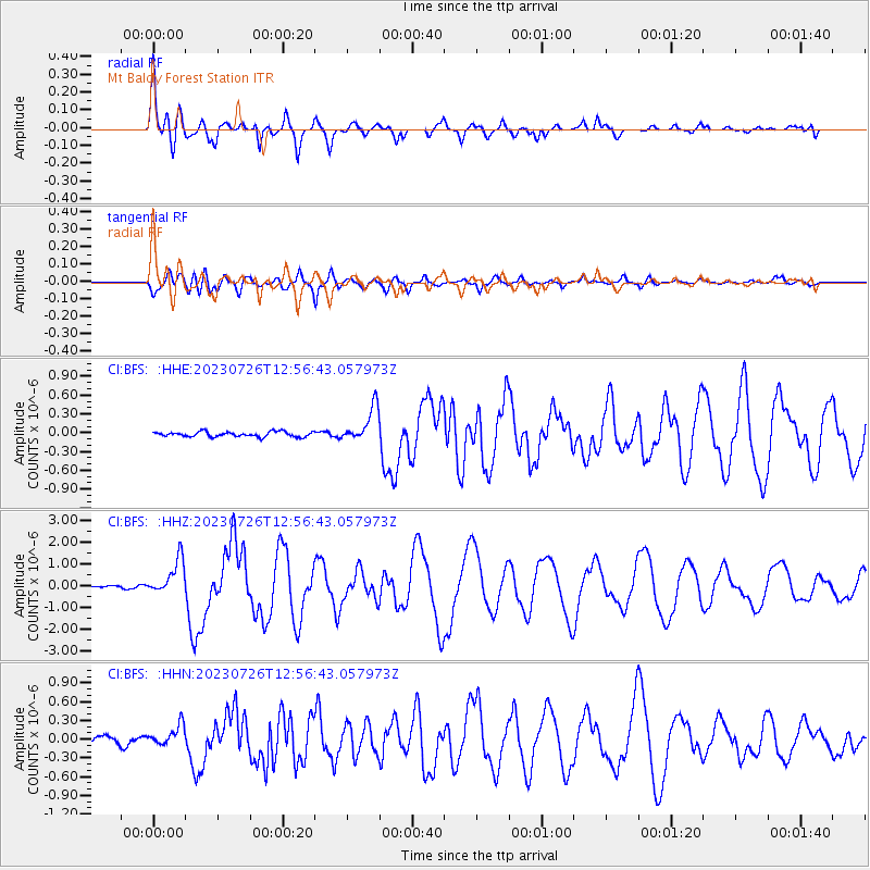
Signal To Noise
| Channel | StoN | STA | LTA |
| CI:BFS: :HHZ:20230726T12:56:43.057973Z | 14.003296 | 8.20429E-7 | 5.8588277E-8 |
| CI:BFS: :HHN:20230726T12:56:43.057973Z | 3.1081831 | 1.6211055E-7 | 5.2156047E-8 |
| CI:BFS: :HHE:20230726T12:56:43.057973Z | 6.9056177 | 2.7707264E-7 | 4.012279E-8 |
| Arrivals |
| Ps | 2.1 SECOND |
| PpPs | 7.6 SECOND |
| PsPs/PpSs | 9.6 SECOND |


