You are here: Home > Network List > G - GEOSCOPE Stations List
> Station INU Inuyama, Japan > Earthquake Result Viewer
INU Inuyama, Japan - Earthquake Result Viewer
| Earthquake location: |
Vanuatu Islands |
| Earthquake latitude/longitude: |
-14.8/167.9 |
| Earthquake time(UTC): |
2023/07/26 (207) 12:44:35 GMT |
| Earthquake Depth: |
13 km |
| Earthquake Magnitude: |
6.4 mww |
| Earthquake Catalog/Contributor: |
NEIC PDE/us |
|
| Network: |
G GEOSCOPE |
| Station: |
INU Inuyama, Japan |
| Lat/Lon: |
35.35 N/137.03 E |
| Elevation: |
132 m |
|
| Distance: |
57.8 deg |
| Az: |
330.266 deg |
| Baz: |
144.058 deg |
| Ray Param: |
0.063253485 |
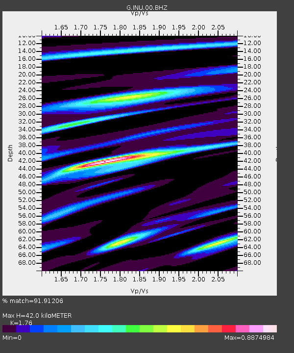
| Estimated Moho Depth: |
42.0 km |
| Estimated Crust Vp/Vs: |
1.76 |
| Assumed Crust Vp: |
6.461 km/s |
| Estimated Crust Vs: |
3.671 km/s |
| Estimated Crust Poisson's Ratio: |
0.26 |
|
| Radial Match: |
91.91206 % |
| Radial Bump: |
338 |
| Transverse Match: |
85.64885 % |
| Transverse Bump: |
400 |
| SOD ConfigId: |
31937991 |
| Insert Time: |
2023-08-09 13:02:53.587 +0000 |
| GWidth: |
2.5 |
| Max Bumps: |
400 |
| Tol: |
0.001 |
|
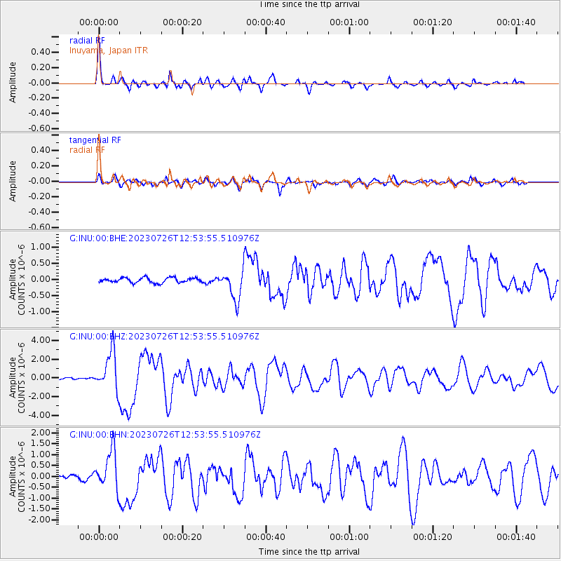
Signal To Noise
| Channel | StoN | STA | LTA |
| G:INU:00:BHZ:20230726T12:53:55.510976Z | 22.884123 | 2.1408425E-6 | 9.3551435E-8 |
| G:INU:00:BHN:20230726T12:53:55.510976Z | 6.876998 | 9.1479745E-7 | 1.330228E-7 |
| G:INU:00:BHE:20230726T12:53:55.510976Z | 6.286356 | 4.769799E-7 | 7.587542E-8 |
| Arrivals |
| Ps | 5.2 SECOND |
| PpPs | 17 SECOND |
| PsPs/PpSs | 22 SECOND |


