You are here: Home > Network List > TX - Texas Seismological Network Stations List
> Station EF04 Eagle Ford 04 > Earthquake Result Viewer
EF04 Eagle Ford 04 - Earthquake Result Viewer
| Earthquake location: |
Southern Alaska |
| Earthquake latitude/longitude: |
61.3/-149.9 |
| Earthquake time(UTC): |
2018/11/30 (334) 17:29:28 GMT |
| Earthquake Depth: |
43 km |
| Earthquake Magnitude: |
6.6 ml |
| Earthquake Catalog/Contributor: |
NEIC PDE/ak |
|
| Network: |
TX Texas Seismological Network |
| Station: |
EF04 Eagle Ford 04 |
| Lat/Lon: |
29.21 N/97.79 W |
| Elevation: |
116 m |
|
| Distance: |
46.8 deg |
| Az: |
108.87 deg |
| Baz: |
328.536 deg |
| Ray Param: |
0.070284106 |
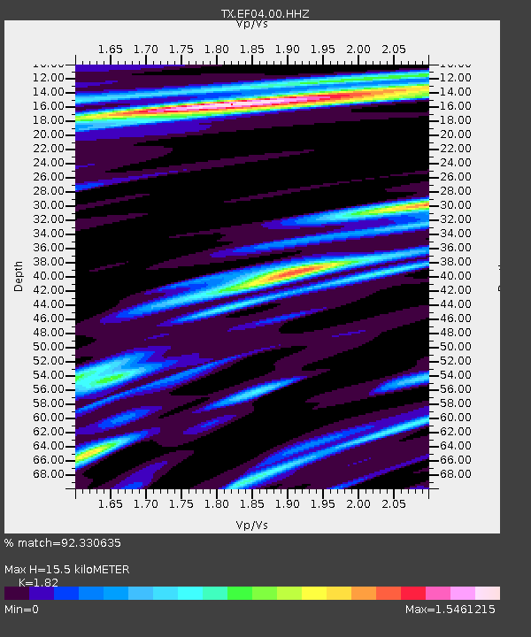
| Estimated Moho Depth: |
15.5 km |
| Estimated Crust Vp/Vs: |
1.82 |
| Assumed Crust Vp: |
5.78 km/s |
| Estimated Crust Vs: |
3.176 km/s |
| Estimated Crust Poisson's Ratio: |
0.28 |
|
| Radial Match: |
92.330635 % |
| Radial Bump: |
400 |
| Transverse Match: |
83.10758 % |
| Transverse Bump: |
400 |
| SOD ConfigId: |
3165032 |
| Insert Time: |
2018-12-14 17:41:52.801 +0000 |
| GWidth: |
2.5 |
| Max Bumps: |
400 |
| Tol: |
0.001 |
|

Signal To Noise
| Channel | StoN | STA | LTA |
| TX:EF04:00:HHZ:20181130T17:37:23.910009Z | 157.30693 | 2.9339224E-5 | 1.8650942E-7 |
| TX:EF04:00:HH1:20181130T17:37:23.910009Z | 14.114853 | 5.9146537E-6 | 4.1903758E-7 |
| TX:EF04:00:HH2:20181130T17:37:23.910009Z | 3.9318075 | 3.3517144E-6 | 8.5246154E-7 |
| Arrivals |
| Ps | 2.3 SECOND |
| PpPs | 7.2 SECOND |
| PsPs/PpSs | 9.5 SECOND |


