You are here: Home > Network List > IW - Intermountain West Stations List
> Station DLMT Dillon, Montana, USA > Earthquake Result Viewer
DLMT Dillon, Montana, USA - Earthquake Result Viewer

| Earthquake location: |
Vanuatu Islands |
| Earthquake latitude/longitude: |
-14.8/167.9 |
| Earthquake time(UTC): |
2023/07/26 (207) 12:44:35 GMT |
| Earthquake Depth: |
13 km |
| Earthquake Magnitude: |
6.4 mww |
| Earthquake Catalog/Contributor: |
NEIC PDE/us |
|
| Network: |
IW Intermountain West |
| Station: |
DLMT Dillon, Montana, USA |
| Lat/Lon: |
45.36 N/112.60 W |
| Elevation: |
1569 m |
|
| Distance: |
93.2 deg |
| Az: |
43.965 deg |
| Baz: |
252.295 deg |
| Ray Param: |
0.041324392 |
| Estimated Moho Depth: |
33.5 km |
| Estimated Crust Vp/Vs: |
1.75 |
| Assumed Crust Vp: |
6.577 km/s |
| Estimated Crust Vs: |
3.758 km/s |
| Estimated Crust Poisson's Ratio: |
0.26 |
|
| Radial Match: |
89.65647 % |
| Radial Bump: |
400 |
| Transverse Match: |
85.098434 % |
| Transverse Bump: |
400 |
| SOD ConfigId: |
31937991 |
| Insert Time: |
2023-08-09 13:04:52.399 +0000 |
| GWidth: |
2.5 |
| Max Bumps: |
400 |
| Tol: |
0.001 |
|
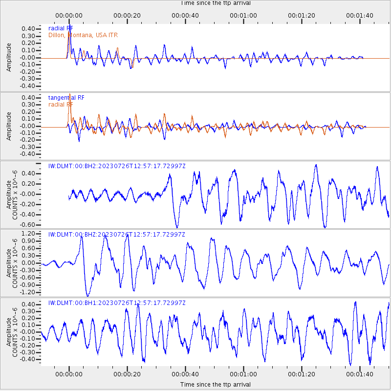
Signal To Noise
| Channel | StoN | STA | LTA |
| IW:DLMT:00:BHZ:20230726T12:57:17.72997Z | 8.469576 | 4.607907E-7 | 5.44054E-8 |
| IW:DLMT:00:BH1:20230726T12:57:17.72997Z | 1.6841351 | 9.306389E-8 | 5.525916E-8 |
| IW:DLMT:00:BH2:20230726T12:57:17.72997Z | 2.2735157 | 1.5898858E-7 | 6.993072E-8 |
| Arrivals |
| Ps | 3.9 SECOND |
| PpPs | 14 SECOND |
| PsPs/PpSs | 18 SECOND |


