You are here: Home > Network List > TA - USArray Transportable Network (new EarthScope stations) Stations List
> Station V37A Hulbert, OK, USA > Earthquake Result Viewer
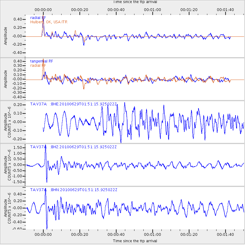
V37A Hulbert, OK, USA - Earthquake Result Viewer
*The percent match for this event was below the threshold and hence no stack was calculated.
| Earthquake location: |
Near Coast Of Central Chile |
| Earthquake latitude/longitude: |
-37.8/-73.3 |
| Earthquake time(UTC): |
2010/06/29 (180) 01:40:00 GMT |
| Earthquake Depth: |
17 km |
| Earthquake Magnitude: |
6.0 MB, 5.2 MS, 5.5 MW, 6.1 ML |
| Earthquake Catalog/Contributor: |
WHDF/NEIC |
|
| Network: |
TA USArray Transportable Network (new EarthScope stations) |
| Station: |
V37A Hulbert, OK, USA |
| Lat/Lon: |
35.88 N/95.14 W |
| Elevation: |
219 m |
|
| Distance: |
76.1 deg |
| Az: |
341.848 deg |
| Baz: |
162.318 deg |
| Ray Param: |
$rayparam |
*The percent match for this event was below the threshold and hence was not used in the summary stack. |
|
| Radial Match: |
61.580887 % |
| Radial Bump: |
400 |
| Transverse Match: |
65.08634 % |
| Transverse Bump: |
376 |
| SOD ConfigId: |
318645 |
| Insert Time: |
2010-11-29 20:15:07.070 +0000 |
| GWidth: |
2.5 |
| Max Bumps: |
400 |
| Tol: |
0.001 |
|
Signal To Noise
| Channel | StoN | STA | LTA |
| TA:V37A: :BHZ:20100629T01:51:15.925022Z | 9.587896 | 6.501651E-7 | 6.781102E-8 |
| TA:V37A: :BHN:20100629T01:51:15.925022Z | 4.3703136 | 2.4332013E-7 | 5.5675663E-8 |
| TA:V37A: :BHE:20100629T01:51:15.925022Z | 1.3043226 | 9.3579956E-8 | 7.174602E-8 |
| Arrivals |
| Ps | |
| PpPs | |
| PsPs/PpSs | |


