You are here: Home > Network List > UW - Pacific Northwest Regional Seismic Network Stations List
> Station GUEM Guemes Island, WA, USA > Earthquake Result Viewer
GUEM Guemes Island, WA, USA - Earthquake Result Viewer
| Earthquake location: |
Vanuatu Islands |
| Earthquake latitude/longitude: |
-14.8/167.9 |
| Earthquake time(UTC): |
2023/07/26 (207) 12:44:35 GMT |
| Earthquake Depth: |
13 km |
| Earthquake Magnitude: |
6.4 mww |
| Earthquake Catalog/Contributor: |
NEIC PDE/us |
|
| Network: |
UW Pacific Northwest Regional Seismic Network |
| Station: |
GUEM Guemes Island, WA, USA |
| Lat/Lon: |
48.55 N/122.63 W |
| Elevation: |
52 m |
|
| Distance: |
87.9 deg |
| Az: |
38.509 deg |
| Baz: |
245.024 deg |
| Ray Param: |
0.042978607 |
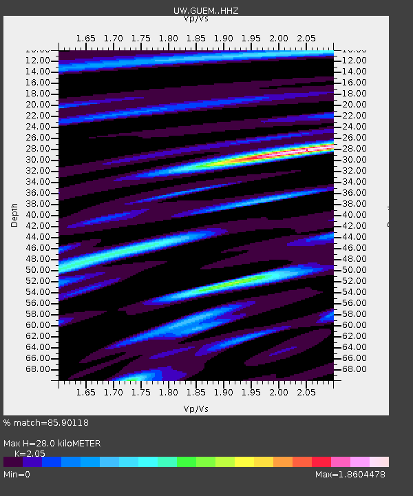
| Estimated Moho Depth: |
28.0 km |
| Estimated Crust Vp/Vs: |
2.05 |
| Assumed Crust Vp: |
6.566 km/s |
| Estimated Crust Vs: |
3.203 km/s |
| Estimated Crust Poisson's Ratio: |
0.34 |
|
| Radial Match: |
85.90118 % |
| Radial Bump: |
400 |
| Transverse Match: |
77.399536 % |
| Transverse Bump: |
400 |
| SOD ConfigId: |
31937991 |
| Insert Time: |
2023-08-09 13:15:33.524 +0000 |
| GWidth: |
2.5 |
| Max Bumps: |
400 |
| Tol: |
0.001 |
|

Signal To Noise
| Channel | StoN | STA | LTA |
| UW:GUEM: :HHZ:20230726T12:56:53.359975Z | 8.961906 | 9.439423E-7 | 1.053283E-7 |
| UW:GUEM: :HHN:20230726T12:56:53.359975Z | 1.0587775 | 2.0119961E-7 | 1.9003012E-7 |
| UW:GUEM: :HHE:20230726T12:56:53.359975Z | 2.3329222 | 3.9221283E-7 | 1.6812083E-7 |
| Arrivals |
| Ps | 4.6 SECOND |
| PpPs | 13 SECOND |
| PsPs/PpSs | 17 SECOND |


