You are here: Home > Network List > UW - Pacific Northwest Regional Seismic Network Stations List
> Station PAN4H Panhandle 4H Camp, Shelton, WA, USA > Earthquake Result Viewer
PAN4H Panhandle 4H Camp, Shelton, WA, USA - Earthquake Result Viewer
| Earthquake location: |
Vanuatu Islands |
| Earthquake latitude/longitude: |
-14.8/167.9 |
| Earthquake time(UTC): |
2023/07/26 (207) 12:44:35 GMT |
| Earthquake Depth: |
13 km |
| Earthquake Magnitude: |
6.4 mww |
| Earthquake Catalog/Contributor: |
NEIC PDE/us |
|
| Network: |
UW Pacific Northwest Regional Seismic Network |
| Station: |
PAN4H Panhandle 4H Camp, Shelton, WA, USA |
| Lat/Lon: |
47.18 N/123.27 W |
| Elevation: |
132 m |
|
| Distance: |
86.9 deg |
| Az: |
39.568 deg |
| Baz: |
244.599 deg |
| Ray Param: |
0.04368773 |
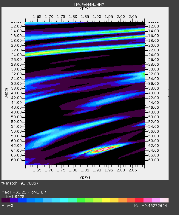
| Estimated Moho Depth: |
63.25 km |
| Estimated Crust Vp/Vs: |
1.93 |
| Assumed Crust Vp: |
6.566 km/s |
| Estimated Crust Vs: |
3.407 km/s |
| Estimated Crust Poisson's Ratio: |
0.32 |
|
| Radial Match: |
91.76867 % |
| Radial Bump: |
364 |
| Transverse Match: |
85.78961 % |
| Transverse Bump: |
400 |
| SOD ConfigId: |
31937991 |
| Insert Time: |
2023-08-09 13:16:59.310 +0000 |
| GWidth: |
2.5 |
| Max Bumps: |
400 |
| Tol: |
0.001 |
|

Signal To Noise
| Channel | StoN | STA | LTA |
| UW:PAN4H: :HHZ:20230726T12:56:48.679982Z | 12.362179 | 8.676183E-7 | 7.018328E-8 |
| UW:PAN4H: :HHN:20230726T12:56:48.679982Z | 2.0645852 | 1.426285E-7 | 6.908336E-8 |
| UW:PAN4H: :HHE:20230726T12:56:48.679982Z | 5.3217216 | 3.0567617E-7 | 5.743934E-8 |
| Arrivals |
| Ps | 9.1 SECOND |
| PpPs | 28 SECOND |
| PsPs/PpSs | 37 SECOND |


