You are here: Home > Network List > UW - Pacific Northwest Regional Seismic Network Stations List
> Station RADR Radar Ridge, Naselle, WA > Earthquake Result Viewer
RADR Radar Ridge, Naselle, WA - Earthquake Result Viewer
| Earthquake location: |
Vanuatu Islands |
| Earthquake latitude/longitude: |
-14.8/167.9 |
| Earthquake time(UTC): |
2023/07/26 (207) 12:44:35 GMT |
| Earthquake Depth: |
13 km |
| Earthquake Magnitude: |
6.4 mww |
| Earthquake Catalog/Contributor: |
NEIC PDE/us |
|
| Network: |
UW Pacific Northwest Regional Seismic Network |
| Station: |
RADR Radar Ridge, Naselle, WA |
| Lat/Lon: |
46.42 N/123.80 W |
| Elevation: |
591 m |
|
| Distance: |
86.3 deg |
| Az: |
40.092 deg |
| Baz: |
244.245 deg |
| Ray Param: |
0.044162624 |
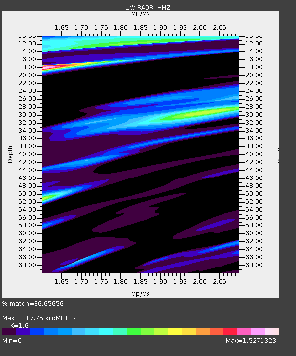
| Estimated Moho Depth: |
17.75 km |
| Estimated Crust Vp/Vs: |
1.60 |
| Assumed Crust Vp: |
6.566 km/s |
| Estimated Crust Vs: |
4.104 km/s |
| Estimated Crust Poisson's Ratio: |
0.18 |
|
| Radial Match: |
86.65656 % |
| Radial Bump: |
400 |
| Transverse Match: |
82.32626 % |
| Transverse Bump: |
400 |
| SOD ConfigId: |
31937991 |
| Insert Time: |
2023-08-09 13:17:07.195 +0000 |
| GWidth: |
2.5 |
| Max Bumps: |
400 |
| Tol: |
0.001 |
|

Signal To Noise
| Channel | StoN | STA | LTA |
| UW:RADR: :HHZ:20230726T12:56:45.489979Z | 4.932917 | 1.042177E-6 | 2.1126992E-7 |
| UW:RADR: :HHN:20230726T12:56:45.489979Z | 0.9969876 | 2.0219282E-7 | 2.0280375E-7 |
| UW:RADR: :HHE:20230726T12:56:45.489979Z | 1.372403 | 3.6809158E-7 | 2.6820956E-7 |
| Arrivals |
| Ps | 1.7 SECOND |
| PpPs | 6.8 SECOND |
| PsPs/PpSs | 8.5 SECOND |


