You are here: Home > Network List > UW - Pacific Northwest Regional Seismic Network Stations List
> Station TBLMT Table Mt, Ellensburg, WA, USA > Earthquake Result Viewer
TBLMT Table Mt, Ellensburg, WA, USA - Earthquake Result Viewer
| Earthquake location: |
Vanuatu Islands |
| Earthquake latitude/longitude: |
-14.8/167.9 |
| Earthquake time(UTC): |
2023/07/26 (207) 12:44:35 GMT |
| Earthquake Depth: |
13 km |
| Earthquake Magnitude: |
6.4 mww |
| Earthquake Catalog/Contributor: |
NEIC PDE/us |
|
| Network: |
UW Pacific Northwest Regional Seismic Network |
| Station: |
TBLMT Table Mt, Ellensburg, WA, USA |
| Lat/Lon: |
47.17 N/120.60 W |
| Elevation: |
1088 m |
|
| Distance: |
88.6 deg |
| Az: |
40.324 deg |
| Baz: |
246.581 deg |
| Ray Param: |
0.042467427 |
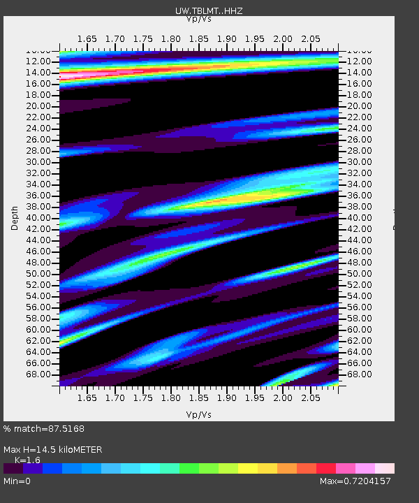
| Estimated Moho Depth: |
14.5 km |
| Estimated Crust Vp/Vs: |
1.60 |
| Assumed Crust Vp: |
6.597 km/s |
| Estimated Crust Vs: |
4.123 km/s |
| Estimated Crust Poisson's Ratio: |
0.18 |
|
| Radial Match: |
87.5168 % |
| Radial Bump: |
369 |
| Transverse Match: |
87.5223 % |
| Transverse Bump: |
346 |
| SOD ConfigId: |
31937991 |
| Insert Time: |
2023-08-09 13:17:42.647 +0000 |
| GWidth: |
2.5 |
| Max Bumps: |
400 |
| Tol: |
0.001 |
|

Signal To Noise
| Channel | StoN | STA | LTA |
| UW:TBLMT: :HHZ:20230726T12:56:56.609975Z | 9.470182 | 9.466656E-7 | 9.9962755E-8 |
| UW:TBLMT: :HHN:20230726T12:56:56.609975Z | 1.8426776 | 1.6774118E-7 | 9.103121E-8 |
| UW:TBLMT: :HHE:20230726T12:56:56.609975Z | 2.3046026 | 2.3284628E-7 | 1.0103533E-7 |
| Arrivals |
| Ps | 1.4 SECOND |
| PpPs | 5.6 SECOND |
| PsPs/PpSs | 6.9 SECOND |


