You are here: Home > Network List > TX - Texas Seismological Network Stations List
> Station SN04 Snyder 4 > Earthquake Result Viewer
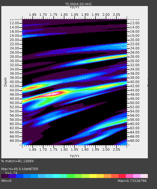
SN04 Snyder 4 - Earthquake Result Viewer
| Earthquake location: |
Southern Alaska |
| Earthquake latitude/longitude: |
61.3/-149.9 |
| Earthquake time(UTC): |
2018/11/30 (334) 17:29:28 GMT |
| Earthquake Depth: |
43 km |
| Earthquake Magnitude: |
6.6 ml |
| Earthquake Catalog/Contributor: |
NEIC PDE/ak |
|
| Network: |
TX Texas Seismological Network |
| Station: |
SN04 Snyder 4 |
| Lat/Lon: |
32.90 N/100.87 W |
| Elevation: |
716 m |
|
| Distance: |
42.3 deg |
| Az: |
109.276 deg |
| Baz: |
327.243 deg |
| Ray Param: |
0.07314707 |
| Estimated Moho Depth: |
45.5 km |
| Estimated Crust Vp/Vs: |
1.74 |
| Assumed Crust Vp: |
6.426 km/s |
| Estimated Crust Vs: |
3.693 km/s |
| Estimated Crust Poisson's Ratio: |
0.25 |
|
| Radial Match: |
91.18894 % |
| Radial Bump: |
400 |
| Transverse Match: |
91.778885 % |
| Transverse Bump: |
400 |
| SOD ConfigId: |
3165032 |
| Insert Time: |
2018-12-14 17:42:54.335 +0000 |
| GWidth: |
2.5 |
| Max Bumps: |
400 |
| Tol: |
0.001 |
|

Signal To Noise
| Channel | StoN | STA | LTA |
| TX:SN04:00:HHZ:20181130T17:36:47.940007Z | 9.509131 | 9.491229E-6 | 9.981175E-7 |
| TX:SN04:00:HH1:20181130T17:36:47.940007Z | 4.583974 | 3.2050425E-6 | 6.991843E-7 |
| TX:SN04:00:HH2:20181130T17:36:47.940007Z | 9.250468 | 5.9112426E-6 | 6.390209E-7 |
| Arrivals |
| Ps | 5.6 SECOND |
| PpPs | 18 SECOND |
| PsPs/PpSs | 24 SECOND |


