You are here: Home > Network List > UW - Pacific Northwest Regional Seismic Network Stations List
> Station UMAT Pilot Rock, OR, USA > Earthquake Result Viewer
UMAT Pilot Rock, OR, USA - Earthquake Result Viewer

| Earthquake location: |
Vanuatu Islands |
| Earthquake latitude/longitude: |
-14.8/167.9 |
| Earthquake time(UTC): |
2023/07/26 (207) 12:44:35 GMT |
| Earthquake Depth: |
13 km |
| Earthquake Magnitude: |
6.4 mww |
| Earthquake Catalog/Contributor: |
NEIC PDE/us |
|
| Network: |
UW Pacific Northwest Regional Seismic Network |
| Station: |
UMAT Pilot Rock, OR, USA |
| Lat/Lon: |
45.29 N/118.96 W |
| Elevation: |
1318 m |
|
| Distance: |
88.9 deg |
| Az: |
42.501 deg |
| Baz: |
247.809 deg |
| Ray Param: |
0.04223364 |
| Estimated Moho Depth: |
37.0 km |
| Estimated Crust Vp/Vs: |
1.74 |
| Assumed Crust Vp: |
6.571 km/s |
| Estimated Crust Vs: |
3.782 km/s |
| Estimated Crust Poisson's Ratio: |
0.25 |
|
| Radial Match: |
93.14216 % |
| Radial Bump: |
366 |
| Transverse Match: |
89.220215 % |
| Transverse Bump: |
334 |
| SOD ConfigId: |
31937991 |
| Insert Time: |
2023-08-09 13:17:58.897 +0000 |
| GWidth: |
2.5 |
| Max Bumps: |
400 |
| Tol: |
0.001 |
|
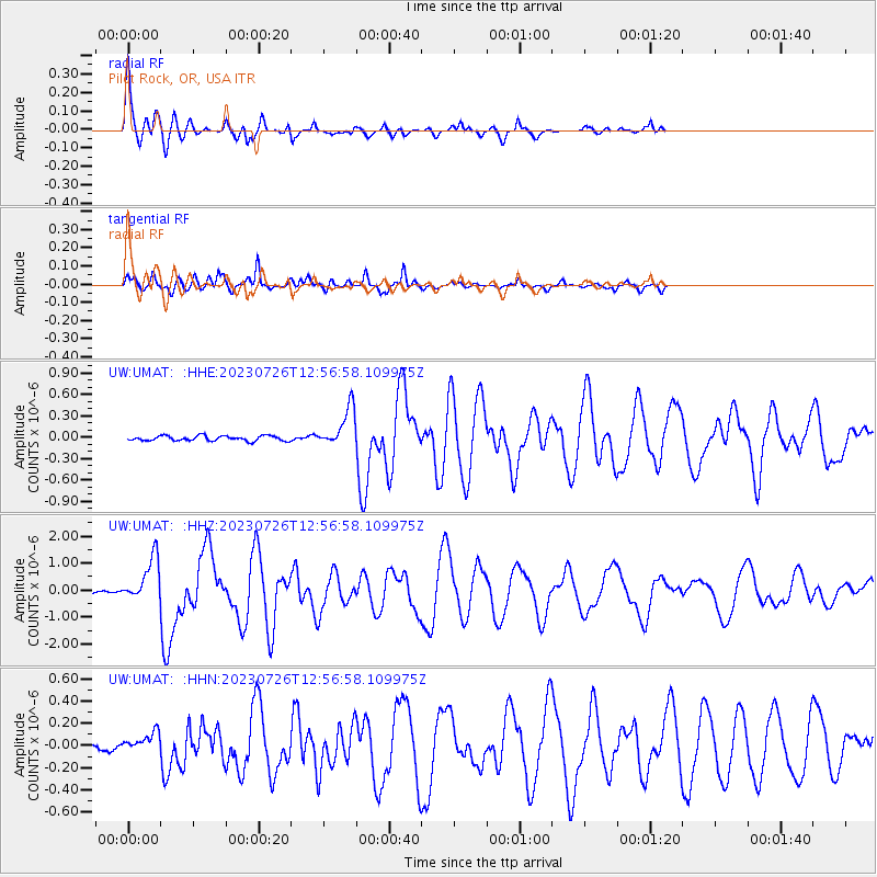
Signal To Noise
| Channel | StoN | STA | LTA |
| UW:UMAT: :HHZ:20230726T12:56:58.109975Z | 16.468084 | 8.2764893E-7 | 5.0257754E-8 |
| UW:UMAT: :HHN:20230726T12:56:58.109975Z | 1.8410811 | 8.3376136E-8 | 4.528651E-8 |
| UW:UMAT: :HHE:20230726T12:56:58.109975Z | 7.8952265 | 2.7327113E-7 | 3.4612196E-8 |
| Arrivals |
| Ps | 4.2 SECOND |
| PpPs | 15 SECOND |
| PsPs/PpSs | 19 SECOND |


