You are here: Home > Network List > UW - Pacific Northwest Regional Seismic Network Stations List
> Station YPT Yellepit > Earthquake Result Viewer
YPT Yellepit - Earthquake Result Viewer
| Earthquake location: |
Vanuatu Islands |
| Earthquake latitude/longitude: |
-14.8/167.9 |
| Earthquake time(UTC): |
2023/07/26 (207) 12:44:35 GMT |
| Earthquake Depth: |
13 km |
| Earthquake Magnitude: |
6.4 mww |
| Earthquake Catalog/Contributor: |
NEIC PDE/us |
|
| Network: |
UW Pacific Northwest Regional Seismic Network |
| Station: |
YPT Yellepit |
| Lat/Lon: |
46.05 N/118.96 W |
| Elevation: |
330 m |
|
| Distance: |
89.2 deg |
| Az: |
41.798 deg |
| Baz: |
247.794 deg |
| Ray Param: |
0.04202818 |
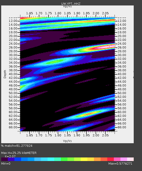
| Estimated Moho Depth: |
25.25 km |
| Estimated Crust Vp/Vs: |
2.07 |
| Assumed Crust Vp: |
6.419 km/s |
| Estimated Crust Vs: |
3.101 km/s |
| Estimated Crust Poisson's Ratio: |
0.35 |
|
| Radial Match: |
91.277824 % |
| Radial Bump: |
400 |
| Transverse Match: |
82.26641 % |
| Transverse Bump: |
400 |
| SOD ConfigId: |
31937991 |
| Insert Time: |
2023-08-09 13:18:23.044 +0000 |
| GWidth: |
2.5 |
| Max Bumps: |
400 |
| Tol: |
0.001 |
|

Signal To Noise
| Channel | StoN | STA | LTA |
| UW:YPT: :HHZ:20230726T12:56:59.439992Z | 12.252644 | 8.2987464E-7 | 6.773025E-8 |
| UW:YPT: :HHN:20230726T12:56:59.439992Z | 2.7847352 | 1.2129891E-7 | 4.3558508E-8 |
| UW:YPT: :HHE:20230726T12:56:59.439992Z | 5.275274 | 2.5687757E-7 | 4.8694638E-8 |
| Arrivals |
| Ps | 4.3 SECOND |
| PpPs | 12 SECOND |
| PsPs/PpSs | 16 SECOND |


