You are here: Home > Network List > TA - USArray Transportable Network (new EarthScope stations) Stations List
> Station 534A Blanco, TX, USA > Earthquake Result Viewer
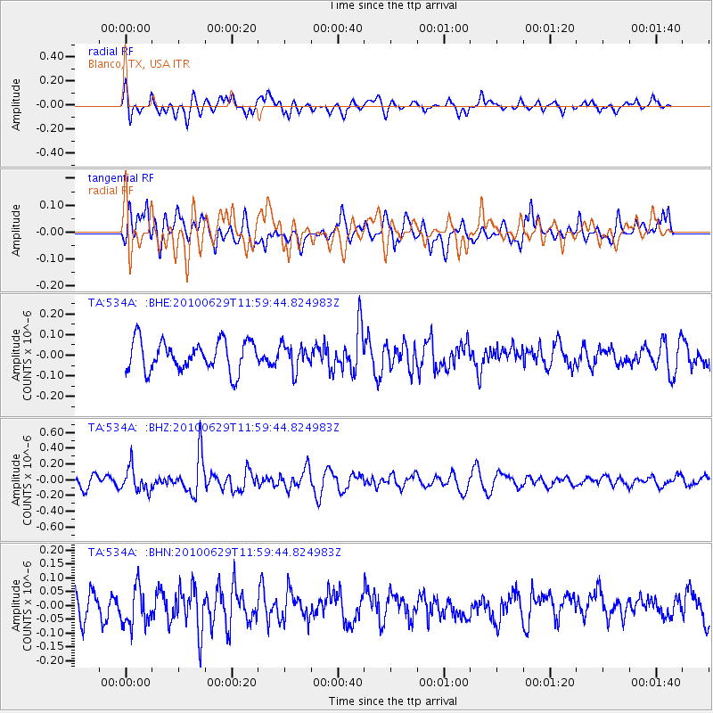
534A Blanco, TX, USA - Earthquake Result Viewer
*The percent match for this event was below the threshold and hence no stack was calculated.
| Earthquake location: |
Kuril Islands |
| Earthquake latitude/longitude: |
48.3/154.3 |
| Earthquake time(UTC): |
2010/06/29 (180) 11:48:19 GMT |
| Earthquake Depth: |
43 km |
| Earthquake Magnitude: |
5.5 MB, 4.9 MS, 5.5 MW, 5.3 MW |
| Earthquake Catalog/Contributor: |
WHDF/NEIC |
|
| Network: |
TA USArray Transportable Network (new EarthScope stations) |
| Station: |
534A Blanco, TX, USA |
| Lat/Lon: |
30.03 N/98.48 W |
| Elevation: |
461 m |
|
| Distance: |
78.5 deg |
| Az: |
57.68 deg |
| Baz: |
319.383 deg |
| Ray Param: |
$rayparam |
*The percent match for this event was below the threshold and hence was not used in the summary stack. |
|
| Radial Match: |
53.60058 % |
| Radial Bump: |
400 |
| Transverse Match: |
48.842033 % |
| Transverse Bump: |
400 |
| SOD ConfigId: |
318645 |
| Insert Time: |
2010-11-29 20:23:36.576 +0000 |
| GWidth: |
2.5 |
| Max Bumps: |
400 |
| Tol: |
0.001 |
|
Signal To Noise
| Channel | StoN | STA | LTA |
| TA:534A: :BHZ:20100629T11:59:44.824983Z | 1.9259324 | 1.524207E-7 | 7.9141245E-8 |
| TA:534A: :BHN:20100629T11:59:44.824983Z | 1.7366097 | 7.021969E-8 | 4.043493E-8 |
| TA:534A: :BHE:20100629T11:59:44.824983Z | 0.8448976 | 6.096321E-8 | 7.215455E-8 |
| Arrivals |
| Ps | |
| PpPs | |
| PsPs/PpSs | |


