You are here: Home > Network List > AV - Alaska Volcano Observatory Stations List
> Station SPCR Ckakachatna River, Mount Spurr, Alaska > Earthquake Result Viewer
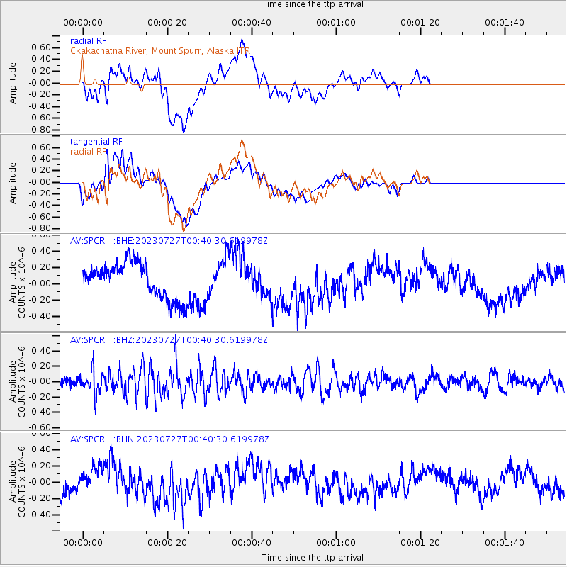
SPCR Ckakachatna River, Mount Spurr, Alaska - Earthquake Result Viewer
*The percent match for this event was below the threshold and hence no stack was calculated.
| Earthquake location: |
Samoa Islands Region |
| Earthquake latitude/longitude: |
-16.3/-172.9 |
| Earthquake time(UTC): |
2023/07/27 (208) 00:28:58 GMT |
| Earthquake Depth: |
10 km |
| Earthquake Magnitude: |
5.5 Mww |
| Earthquake Catalog/Contributor: |
NEIC PDE/us |
|
| Network: |
AV Alaska Volcano Observatory |
| Station: |
SPCR Ckakachatna River, Mount Spurr, Alaska |
| Lat/Lon: |
61.20 N/152.21 W |
| Elevation: |
984 m |
|
| Distance: |
78.9 deg |
| Az: |
10.033 deg |
| Baz: |
200.217 deg |
| Ray Param: |
$rayparam |
*The percent match for this event was below the threshold and hence was not used in the summary stack. |
|
| Radial Match: |
25.702875 % |
| Radial Bump: |
400 |
| Transverse Match: |
28.79131 % |
| Transverse Bump: |
400 |
| SOD ConfigId: |
31937991 |
| Insert Time: |
2023-08-10 00:36:56.134 +0000 |
| GWidth: |
2.5 |
| Max Bumps: |
400 |
| Tol: |
0.001 |
|
Signal To Noise
| Channel | StoN | STA | LTA |
| AV:SPCR: :BHZ:20230727T00:40:30.619978Z | 3.1265996 | 1.4615712E-7 | 4.674635E-8 |
| AV:SPCR: :BHN:20230727T00:40:30.619978Z | 0.94757986 | 1.3380024E-7 | 1.4120208E-7 |
| AV:SPCR: :BHE:20230727T00:40:30.619978Z | 1.0944767 | 2.3370615E-7 | 2.1353233E-7 |
| Arrivals |
| Ps | |
| PpPs | |
| PsPs/PpSs | |


