You are here: Home > Network List > IW - Intermountain West Stations List
> Station MOOW Moose Ponds, Wyoming, USA > Earthquake Result Viewer
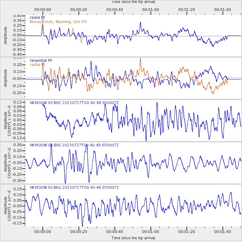
MOOW Moose Ponds, Wyoming, USA - Earthquake Result Viewer
*The percent match for this event was below the threshold and hence no stack was calculated.
| Earthquake location: |
Samoa Islands Region |
| Earthquake latitude/longitude: |
-16.3/-172.9 |
| Earthquake time(UTC): |
2023/07/27 (208) 00:28:58 GMT |
| Earthquake Depth: |
10 km |
| Earthquake Magnitude: |
5.5 Mww |
| Earthquake Catalog/Contributor: |
NEIC PDE/us |
|
| Network: |
IW Intermountain West |
| Station: |
MOOW Moose Ponds, Wyoming, USA |
| Lat/Lon: |
43.75 N/110.74 W |
| Elevation: |
2128 m |
|
| Distance: |
82.3 deg |
| Az: |
40.278 deg |
| Baz: |
238.968 deg |
| Ray Param: |
$rayparam |
*The percent match for this event was below the threshold and hence was not used in the summary stack. |
|
| Radial Match: |
28.644623 % |
| Radial Bump: |
400 |
| Transverse Match: |
49.83118 % |
| Transverse Bump: |
400 |
| SOD ConfigId: |
31937991 |
| Insert Time: |
2023-08-10 00:45:04.899 +0000 |
| GWidth: |
2.5 |
| Max Bumps: |
400 |
| Tol: |
0.001 |
|
Signal To Noise
| Channel | StoN | STA | LTA |
| IW:MOOW:00:BHZ:20230727T00:40:48.650007Z | 3.0039756 | 1.0178339E-7 | 3.3882895E-8 |
| IW:MOOW:00:BH1:20230727T00:40:48.650007Z | 1.1616279 | 4.6161126E-8 | 3.9738307E-8 |
| IW:MOOW:00:BH2:20230727T00:40:48.650007Z | 0.99837655 | 4.3971582E-8 | 4.4043084E-8 |
| Arrivals |
| Ps | |
| PpPs | |
| PsPs/PpSs | |


