You are here: Home > Network List > AU - Australian Seismological Centre Stations List
> Station MANU Manus Island, Papau New Guinea > Earthquake Result Viewer
MANU Manus Island, Papau New Guinea - Earthquake Result Viewer
| Earthquake location: |
South Of Fiji Islands |
| Earthquake latitude/longitude: |
-23.3/179.1 |
| Earthquake time(UTC): |
2010/06/30 (181) 04:31:02 GMT |
| Earthquake Depth: |
581 km |
| Earthquake Magnitude: |
5.8 MB, 6.4 MW, 6.3 MW |
| Earthquake Catalog/Contributor: |
WHDF/NEIC |
|
| Network: |
AU Australian Seismological Centre |
| Station: |
MANU Manus Island, Papau New Guinea |
| Lat/Lon: |
2.04 S/147.37 E |
| Elevation: |
142 m |
|
| Distance: |
37.3 deg |
| Az: |
299.849 deg |
| Baz: |
127.071 deg |
| Ray Param: |
0.07321872 |
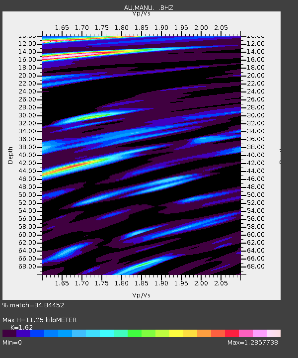
| Estimated Moho Depth: |
11.25 km |
| Estimated Crust Vp/Vs: |
1.62 |
| Assumed Crust Vp: |
4.082 km/s |
| Estimated Crust Vs: |
2.52 km/s |
| Estimated Crust Poisson's Ratio: |
0.19 |
|
| Radial Match: |
84.84452 % |
| Radial Bump: |
400 |
| Transverse Match: |
77.38654 % |
| Transverse Bump: |
400 |
| SOD ConfigId: |
318645 |
| Insert Time: |
2010-11-29 20:32:07.459 +0000 |
| GWidth: |
2.5 |
| Max Bumps: |
400 |
| Tol: |
0.001 |
|

Signal To Noise
| Channel | StoN | STA | LTA |
| AU:MANU: :BHZ:20100630T04:36:55.594998Z | 28.23341 | 2.6442165E-6 | 9.3655586E-8 |
| AU:MANU: :BHN:20100630T04:36:55.594998Z | 6.595666 | 1.1775008E-6 | 1.7852646E-7 |
| AU:MANU: :BHE:20100630T04:36:55.594998Z | 8.760283 | 1.6959294E-6 | 1.9359298E-7 |
| Arrivals |
| Ps | 1.8 SECOND |
| PpPs | 7.0 SECOND |
| PsPs/PpSs | 8.8 SECOND |


