You are here: Home > Network List > CB - China National Seismic Network Stations List
> Station HHC Huhehaote,Neimeng Province > Earthquake Result Viewer
HHC Huhehaote,Neimeng Province - Earthquake Result Viewer
| Earthquake location: |
South Of Fiji Islands |
| Earthquake latitude/longitude: |
-23.3/179.1 |
| Earthquake time(UTC): |
2010/06/30 (181) 04:31:02 GMT |
| Earthquake Depth: |
581 km |
| Earthquake Magnitude: |
5.8 MB, 6.4 MW, 6.3 MW |
| Earthquake Catalog/Contributor: |
WHDF/NEIC |
|
| Network: |
CB China National Seismic Network |
| Station: |
HHC Huhehaote,Neimeng Province |
| Lat/Lon: |
40.85 N/111.56 E |
| Elevation: |
1169 m |
|
| Distance: |
89.4 deg |
| Az: |
315.481 deg |
| Baz: |
121.817 deg |
| Ray Param: |
0.041576087 |
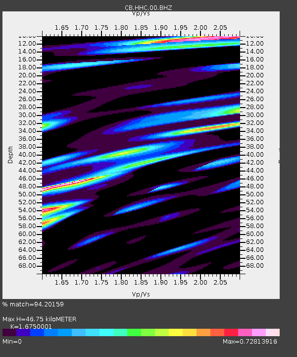
| Estimated Moho Depth: |
46.75 km |
| Estimated Crust Vp/Vs: |
1.68 |
| Assumed Crust Vp: |
6.384 km/s |
| Estimated Crust Vs: |
3.812 km/s |
| Estimated Crust Poisson's Ratio: |
0.22 |
|
| Radial Match: |
94.20159 % |
| Radial Bump: |
400 |
| Transverse Match: |
87.10625 % |
| Transverse Bump: |
400 |
| SOD ConfigId: |
318645 |
| Insert Time: |
2010-11-29 20:33:16.727 +0000 |
| GWidth: |
2.5 |
| Max Bumps: |
400 |
| Tol: |
0.001 |
|

Signal To Noise
| Channel | StoN | STA | LTA |
| CB:HHC:00:BHZ:20100630T04:42:26.43002Z | 8.830934 | 1.409999E-6 | 1.596659E-7 |
| CB:HHC:00:BHN:20100630T04:42:26.43002Z | 1.9064246 | 2.978596E-7 | 1.562399E-7 |
| CB:HHC:00:BHE:20100630T04:42:26.43002Z | 2.8199453 | 5.180802E-7 | 1.8371993E-7 |
| Arrivals |
| Ps | 5.1 SECOND |
| PpPs | 19 SECOND |
| PsPs/PpSs | 24 SECOND |


