You are here: Home > Network List > UU - University of Utah Regional Network Stations List
> Station KNB Kanab, UT, USA > Earthquake Result Viewer
KNB Kanab, UT, USA - Earthquake Result Viewer
| Earthquake location: |
Southern Alaska |
| Earthquake latitude/longitude: |
61.3/-149.9 |
| Earthquake time(UTC): |
2018/11/30 (334) 17:29:28 GMT |
| Earthquake Depth: |
43 km |
| Earthquake Magnitude: |
6.6 ml |
| Earthquake Catalog/Contributor: |
NEIC PDE/ak |
|
| Network: |
UU University of Utah Regional Network |
| Station: |
KNB Kanab, UT, USA |
| Lat/Lon: |
37.02 N/112.82 W |
| Elevation: |
1715 m |
|
| Distance: |
33.6 deg |
| Az: |
119.222 deg |
| Baz: |
328.277 deg |
| Ray Param: |
0.07805115 |
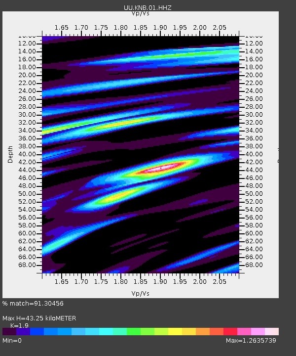
| Estimated Moho Depth: |
43.25 km |
| Estimated Crust Vp/Vs: |
1.90 |
| Assumed Crust Vp: |
6.194 km/s |
| Estimated Crust Vs: |
3.26 km/s |
| Estimated Crust Poisson's Ratio: |
0.31 |
|
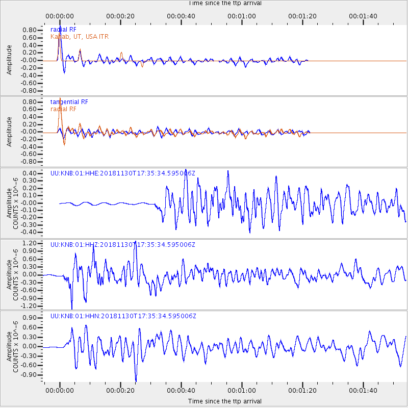
| Radial Match: |
91.30456 % |
| Radial Bump: |
365 |
| Transverse Match: |
78.02425 % |
| Transverse Bump: |
400 |
| SOD ConfigId: |
3165032 |
| Insert Time: |
2018-12-14 17:44:28.059 +0000 |
| GWidth: |
2.5 |
| Max Bumps: |
400 |
| Tol: |
0.001 |
|
Signal To Noise
| Channel | StoN | STA | LTA |
| UU:KNB:01:HHZ:20181130T17:35:34.595006Z | 25.284277 | 3.7107503E-7 | 1.4676119E-8 |
| UU:KNB:01:HHN:20181130T17:35:34.595006Z | 20.498308 | 2.0722311E-7 | 1.0109279E-8 |
| UU:KNB:01:HHE:20181130T17:35:34.595006Z | 7.0898905 | 9.1937785E-8 | 1.2967448E-8 |
| Arrivals |
| Ps | 6.7 SECOND |
| PpPs | 19 SECOND |
| PsPs/PpSs | 26 SECOND |


