You are here: Home > Network List > IW - Intermountain West Stations List
> Station MOOW Moose Ponds, Wyoming, USA > Earthquake Result Viewer
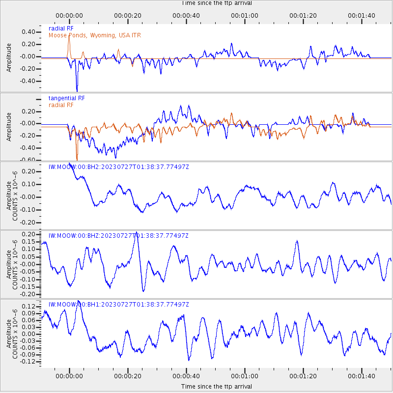
MOOW Moose Ponds, Wyoming, USA - Earthquake Result Viewer
*The percent match for this event was below the threshold and hence no stack was calculated.
| Earthquake location: |
Vanuatu Islands |
| Earthquake latitude/longitude: |
-14.6/167.8 |
| Earthquake time(UTC): |
2023/07/27 (208) 01:25:51 GMT |
| Earthquake Depth: |
10 km |
| Earthquake Magnitude: |
5.5 Mww |
| Earthquake Catalog/Contributor: |
NEIC PDE/us |
|
| Network: |
IW Intermountain West |
| Station: |
MOOW Moose Ponds, Wyoming, USA |
| Lat/Lon: |
43.75 N/110.74 W |
| Elevation: |
2128 m |
|
| Distance: |
93.9 deg |
| Az: |
45.906 deg |
| Baz: |
253.662 deg |
| Ray Param: |
$rayparam |
*The percent match for this event was below the threshold and hence was not used in the summary stack. |
|
| Radial Match: |
57.329826 % |
| Radial Bump: |
400 |
| Transverse Match: |
42.504223 % |
| Transverse Bump: |
400 |
| SOD ConfigId: |
31937991 |
| Insert Time: |
2023-08-10 01:39:10.691 +0000 |
| GWidth: |
2.5 |
| Max Bumps: |
400 |
| Tol: |
0.001 |
|
Signal To Noise
| Channel | StoN | STA | LTA |
| IW:MOOW:00:BHZ:20230727T01:38:37.77497Z | 1.0421106 | 8.9772605E-8 | 8.6144986E-8 |
| IW:MOOW:00:BH1:20230727T01:38:37.77497Z | 1.0997497 | 1.1338869E-7 | 1.03104085E-7 |
| IW:MOOW:00:BH2:20230727T01:38:37.77497Z | 0.5944702 | 5.360618E-8 | 9.017471E-8 |
| Arrivals |
| Ps | |
| PpPs | |
| PsPs/PpSs | |


