You are here: Home > Network List > IW - Intermountain West Stations List
> Station MOOW Moose Ponds, Wyoming, USA > Earthquake Result Viewer
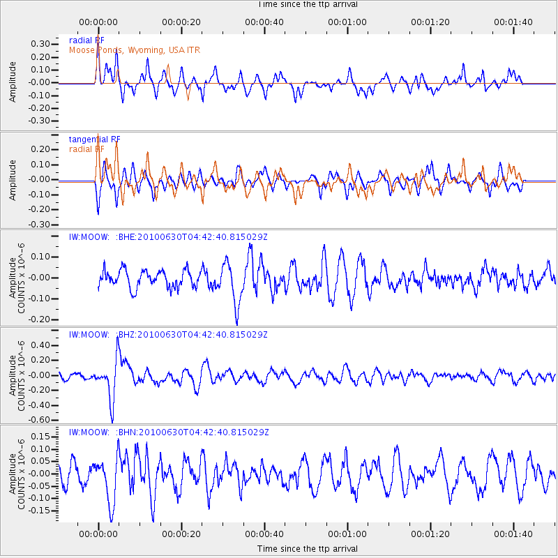
MOOW Moose Ponds, Wyoming, USA - Earthquake Result Viewer
*The percent match for this event was below the threshold and hence no stack was calculated.
| Earthquake location: |
South Of Fiji Islands |
| Earthquake latitude/longitude: |
-23.3/179.1 |
| Earthquake time(UTC): |
2010/06/30 (181) 04:31:02 GMT |
| Earthquake Depth: |
581 km |
| Earthquake Magnitude: |
5.8 MB, 6.4 MW, 6.3 MW |
| Earthquake Catalog/Contributor: |
WHDF/NEIC |
|
| Network: |
IW Intermountain West |
| Station: |
MOOW Moose Ponds, Wyoming, USA |
| Lat/Lon: |
43.75 N/110.74 W |
| Elevation: |
2128 m |
|
| Distance: |
92.6 deg |
| Az: |
43.022 deg |
| Baz: |
239.945 deg |
| Ray Param: |
$rayparam |
*The percent match for this event was below the threshold and hence was not used in the summary stack. |
|
| Radial Match: |
61.07445 % |
| Radial Bump: |
293 |
| Transverse Match: |
61.764866 % |
| Transverse Bump: |
322 |
| SOD ConfigId: |
318645 |
| Insert Time: |
2010-11-29 20:35:58.166 +0000 |
| GWidth: |
2.5 |
| Max Bumps: |
400 |
| Tol: |
0.001 |
|
Signal To Noise
| Channel | StoN | STA | LTA |
| IW:MOOW: :BHZ:20100630T04:42:40.815029Z | 4.6408553 | 2.7111437E-7 | 5.8419054E-8 |
| IW:MOOW: :BHN:20100630T04:42:40.815029Z | 2.3271554 | 9.61189E-8 | 4.1303174E-8 |
| IW:MOOW: :BHE:20100630T04:42:40.815029Z | 2.472261 | 9.8612105E-8 | 3.9887418E-8 |
| Arrivals |
| Ps | |
| PpPs | |
| PsPs/PpSs | |


