You are here: Home > Network List > TA - USArray Transportable Network (new EarthScope stations) Stations List
> Station 334A Lometa, TX, USA > Earthquake Result Viewer
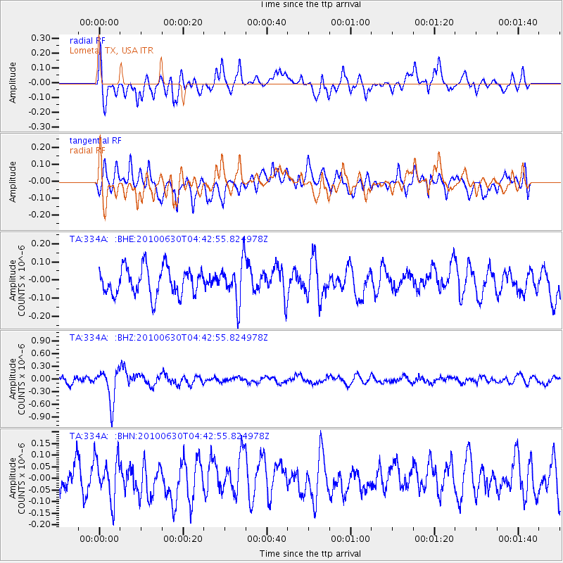
334A Lometa, TX, USA - Earthquake Result Viewer
*The percent match for this event was below the threshold and hence no stack was calculated.
| Earthquake location: |
South Of Fiji Islands |
| Earthquake latitude/longitude: |
-23.3/179.1 |
| Earthquake time(UTC): |
2010/06/30 (181) 04:31:02 GMT |
| Earthquake Depth: |
581 km |
| Earthquake Magnitude: |
5.8 MB, 6.4 MW, 6.3 MW |
| Earthquake Catalog/Contributor: |
WHDF/NEIC |
|
| Network: |
TA USArray Transportable Network (new EarthScope stations) |
| Station: |
334A Lometa, TX, USA |
| Lat/Lon: |
31.33 N/98.24 W |
| Elevation: |
389 m |
|
| Distance: |
95.9 deg |
| Az: |
58.561 deg |
| Baz: |
246.443 deg |
| Ray Param: |
$rayparam |
*The percent match for this event was below the threshold and hence was not used in the summary stack. |
|
| Radial Match: |
61.194153 % |
| Radial Bump: |
400 |
| Transverse Match: |
63.9202 % |
| Transverse Bump: |
400 |
| SOD ConfigId: |
318645 |
| Insert Time: |
2010-11-29 20:38:55.607 +0000 |
| GWidth: |
2.5 |
| Max Bumps: |
400 |
| Tol: |
0.001 |
|
Signal To Noise
| Channel | StoN | STA | LTA |
| TA:334A: :BHZ:20100630T04:42:55.824978Z | 5.773677 | 3.916151E-7 | 6.782768E-8 |
| TA:334A: :BHN:20100630T04:42:55.824978Z | 1.7398498 | 8.904921E-8 | 5.1182123E-8 |
| TA:334A: :BHE:20100630T04:42:55.824978Z | 1.5107043 | 1.14499215E-7 | 7.5791945E-8 |
| Arrivals |
| Ps | |
| PpPs | |
| PsPs/PpSs | |


