You are here: Home > Network List > AK - Alaska Regional Network Stations List
> Station D20K Etivluk River, AK, USA > Earthquake Result Viewer
D20K Etivluk River, AK, USA - Earthquake Result Viewer
| Earthquake location: |
Andaman Islands, India Region |
| Earthquake latitude/longitude: |
10.5/93.5 |
| Earthquake time(UTC): |
2023/07/28 (209) 19:23:48 GMT |
| Earthquake Depth: |
102 km |
| Earthquake Magnitude: |
5.9 mww |
| Earthquake Catalog/Contributor: |
NEIC PDE/us |
|
| Network: |
AK Alaska Regional Network |
| Station: |
D20K Etivluk River, AK, USA |
| Lat/Lon: |
68.71 N/156.61 W |
| Elevation: |
577 m |
|
| Distance: |
87.3 deg |
| Az: |
20.111 deg |
| Baz: |
292.181 deg |
| Ray Param: |
0.043215126 |
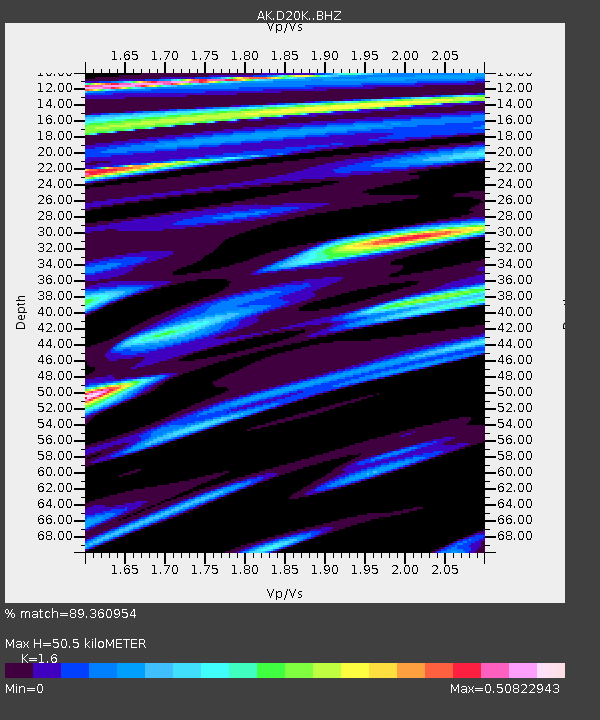
| Estimated Moho Depth: |
50.5 km |
| Estimated Crust Vp/Vs: |
1.60 |
| Assumed Crust Vp: |
6.221 km/s |
| Estimated Crust Vs: |
3.888 km/s |
| Estimated Crust Poisson's Ratio: |
0.18 |
|
| Radial Match: |
89.360954 % |
| Radial Bump: |
400 |
| Transverse Match: |
83.60659 % |
| Transverse Bump: |
400 |
| SOD ConfigId: |
31937991 |
| Insert Time: |
2023-08-11 19:27:27.888 +0000 |
| GWidth: |
2.5 |
| Max Bumps: |
400 |
| Tol: |
0.001 |
|

Signal To Noise
| Channel | StoN | STA | LTA |
| AK:D20K: :BHZ:20230728T19:35:52.30003Z | 4.145522 | 4.1420185E-7 | 9.991548E-8 |
| AK:D20K: :BHN:20230728T19:35:52.30003Z | 1.9034461 | 7.634397E-8 | 4.010829E-8 |
| AK:D20K: :BHE:20230728T19:35:52.30003Z | 2.9260159 | 1.05831525E-7 | 3.6169155E-8 |
| Arrivals |
| Ps | 5.0 SECOND |
| PpPs | 21 SECOND |
| PsPs/PpSs | 26 SECOND |


