You are here: Home > Network List > AK - Alaska Regional Network Stations List
> Station F20K Avaraart Lake, AK, USA > Earthquake Result Viewer
F20K Avaraart Lake, AK, USA - Earthquake Result Viewer
| Earthquake location: |
Andaman Islands, India Region |
| Earthquake latitude/longitude: |
10.5/93.5 |
| Earthquake time(UTC): |
2023/07/28 (209) 19:23:48 GMT |
| Earthquake Depth: |
102 km |
| Earthquake Magnitude: |
5.9 mww |
| Earthquake Catalog/Contributor: |
NEIC PDE/us |
|
| Network: |
AK Alaska Regional Network |
| Station: |
F20K Avaraart Lake, AK, USA |
| Lat/Lon: |
67.05 N/155.73 W |
| Elevation: |
136 m |
|
| Distance: |
88.3 deg |
| Az: |
21.527 deg |
| Baz: |
293.058 deg |
| Ray Param: |
0.04251019 |
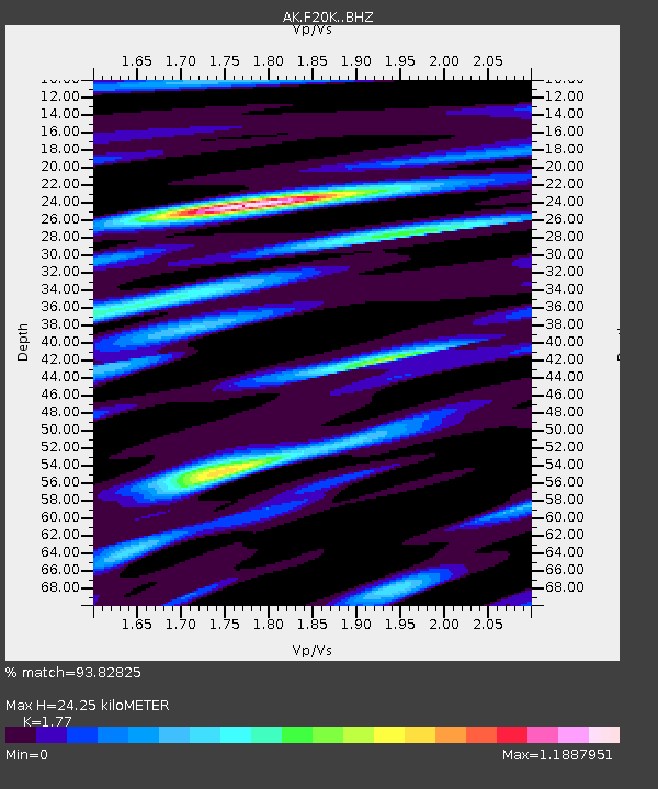
| Estimated Moho Depth: |
24.25 km |
| Estimated Crust Vp/Vs: |
1.77 |
| Assumed Crust Vp: |
6.522 km/s |
| Estimated Crust Vs: |
3.685 km/s |
| Estimated Crust Poisson's Ratio: |
0.27 |
|
| Radial Match: |
93.82825 % |
| Radial Bump: |
353 |
| Transverse Match: |
78.12025 % |
| Transverse Bump: |
400 |
| SOD ConfigId: |
31937991 |
| Insert Time: |
2023-08-11 19:27:46.335 +0000 |
| GWidth: |
2.5 |
| Max Bumps: |
400 |
| Tol: |
0.001 |
|

Signal To Noise
| Channel | StoN | STA | LTA |
| AK:F20K: :BHZ:20230728T19:35:56.840008Z | 6.08716 | 2.5495754E-7 | 4.188448E-8 |
| AK:F20K: :BHN:20230728T19:35:56.840008Z | 1.3195239 | 5.504609E-8 | 4.171663E-8 |
| AK:F20K: :BHE:20230728T19:35:56.840008Z | 3.5951533 | 1.0372684E-7 | 2.8851854E-8 |
| Arrivals |
| Ps | 2.9 SECOND |
| PpPs | 10 SECOND |
| PsPs/PpSs | 13 SECOND |


