You are here: Home > Network List > AK - Alaska Regional Network Stations List
> Station G17K Kiwalik Mountain, AK, USA > Earthquake Result Viewer
G17K Kiwalik Mountain, AK, USA - Earthquake Result Viewer
| Earthquake location: |
Andaman Islands, India Region |
| Earthquake latitude/longitude: |
10.5/93.5 |
| Earthquake time(UTC): |
2023/07/28 (209) 19:23:48 GMT |
| Earthquake Depth: |
102 km |
| Earthquake Magnitude: |
5.9 mww |
| Earthquake Catalog/Contributor: |
NEIC PDE/us |
|
| Network: |
AK Alaska Regional Network |
| Station: |
G17K Kiwalik Mountain, AK, USA |
| Lat/Lon: |
65.50 N/160.65 W |
| Elevation: |
338 m |
|
| Distance: |
86.9 deg |
| Az: |
23.69 deg |
| Baz: |
288.643 deg |
| Ray Param: |
0.04346741 |
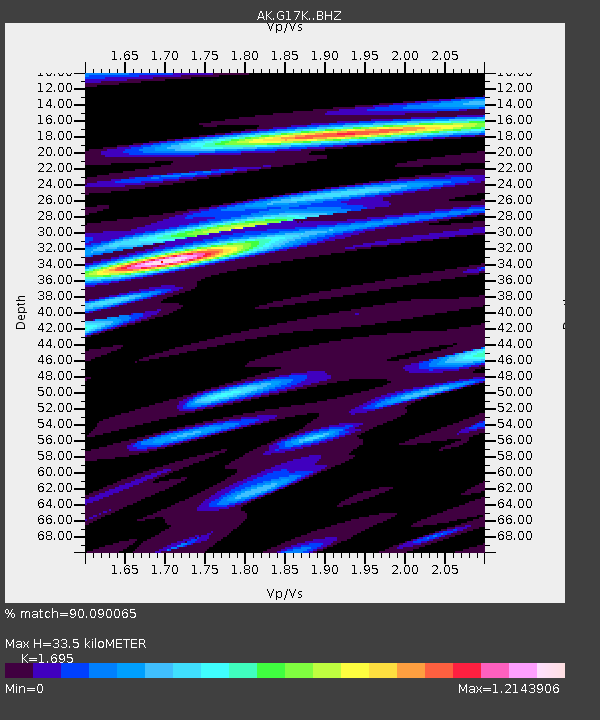
| Estimated Moho Depth: |
33.5 km |
| Estimated Crust Vp/Vs: |
1.70 |
| Assumed Crust Vp: |
6.276 km/s |
| Estimated Crust Vs: |
3.703 km/s |
| Estimated Crust Poisson's Ratio: |
0.23 |
|
| Radial Match: |
90.090065 % |
| Radial Bump: |
310 |
| Transverse Match: |
76.178566 % |
| Transverse Bump: |
400 |
| SOD ConfigId: |
31937991 |
| Insert Time: |
2023-08-11 19:27:53.511 +0000 |
| GWidth: |
2.5 |
| Max Bumps: |
400 |
| Tol: |
0.001 |
|

Signal To Noise
| Channel | StoN | STA | LTA |
| AK:G17K: :BHZ:20230728T19:35:50.579999Z | 3.726172 | 1.7924886E-7 | 4.8105363E-8 |
| AK:G17K: :BHN:20230728T19:35:50.579999Z | 1.5763386 | 3.766967E-8 | 2.389694E-8 |
| AK:G17K: :BHE:20230728T19:35:50.579999Z | 1.8139143 | 7.9686586E-8 | 4.3930736E-8 |
| Arrivals |
| Ps | 3.8 SECOND |
| PpPs | 14 SECOND |
| PsPs/PpSs | 18 SECOND |


