You are here: Home > Network List > AK - Alaska Regional Network Stations List
> Station J20K Nowitna River, AK, USA > Earthquake Result Viewer
J20K Nowitna River, AK, USA - Earthquake Result Viewer
| Earthquake location: |
Andaman Islands, India Region |
| Earthquake latitude/longitude: |
10.5/93.5 |
| Earthquake time(UTC): |
2023/07/28 (209) 19:23:48 GMT |
| Earthquake Depth: |
102 km |
| Earthquake Magnitude: |
5.9 mww |
| Earthquake Catalog/Contributor: |
NEIC PDE/us |
|
| Network: |
AK Alaska Regional Network |
| Station: |
J20K Nowitna River, AK, USA |
| Lat/Lon: |
64.18 N/154.15 W |
| Elevation: |
314 m |
|
| Distance: |
90.0 deg |
| Az: |
23.902 deg |
| Baz: |
294.53 deg |
| Ray Param: |
0.041712403 |
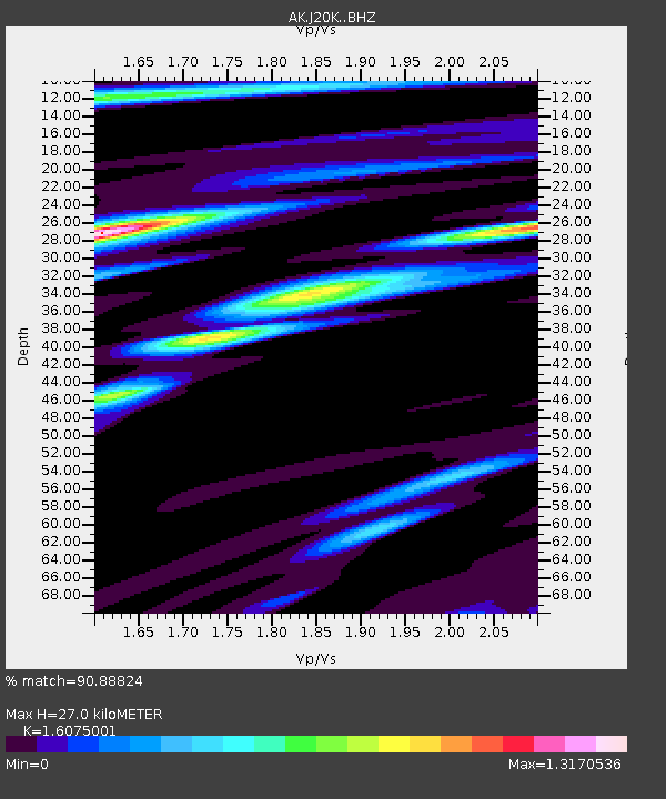
| Estimated Moho Depth: |
27.0 km |
| Estimated Crust Vp/Vs: |
1.61 |
| Assumed Crust Vp: |
6.566 km/s |
| Estimated Crust Vs: |
4.085 km/s |
| Estimated Crust Poisson's Ratio: |
0.18 |
|
| Radial Match: |
90.88824 % |
| Radial Bump: |
400 |
| Transverse Match: |
88.21279 % |
| Transverse Bump: |
400 |
| SOD ConfigId: |
31937991 |
| Insert Time: |
2023-08-11 19:28:28.005 +0000 |
| GWidth: |
2.5 |
| Max Bumps: |
400 |
| Tol: |
0.001 |
|

Signal To Noise
| Channel | StoN | STA | LTA |
| AK:J20K: :BHZ:20230728T19:36:05.059979Z | 3.551903 | 2.2352226E-7 | 6.293028E-8 |
| AK:J20K: :BHN:20230728T19:36:05.059979Z | 2.0125058 | 5.5151038E-8 | 2.7404162E-8 |
| AK:J20K: :BHE:20230728T19:36:05.059979Z | 1.4424235 | 5.8484293E-8 | 4.0545856E-8 |
| Arrivals |
| Ps | 2.6 SECOND |
| PpPs | 10 SECOND |
| PsPs/PpSs | 13 SECOND |


