You are here: Home > Network List > AK - Alaska Regional Network Stations List
> Station F21K Alatna River, AK, USA > Earthquake Result Viewer
F21K Alatna River, AK, USA - Earthquake Result Viewer
| Earthquake location: |
Off Coast Of Central America |
| Earthquake latitude/longitude: |
12.7/-90.9 |
| Earthquake time(UTC): |
2023/07/30 (211) 01:10:29 GMT |
| Earthquake Depth: |
10 km |
| Earthquake Magnitude: |
5.7 Mww |
| Earthquake Catalog/Contributor: |
NEIC PDE/us |
|
| Network: |
AK Alaska Regional Network |
| Station: |
F21K Alatna River, AK, USA |
| Lat/Lon: |
67.22 N/153.48 W |
| Elevation: |
597 m |
|
| Distance: |
67.9 deg |
| Az: |
338.088 deg |
| Baz: |
110.752 deg |
| Ray Param: |
0.05668305 |
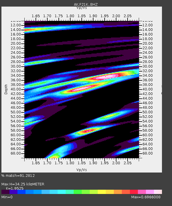
| Estimated Moho Depth: |
34.25 km |
| Estimated Crust Vp/Vs: |
1.95 |
| Assumed Crust Vp: |
6.455 km/s |
| Estimated Crust Vs: |
3.306 km/s |
| Estimated Crust Poisson's Ratio: |
0.32 |
|
| Radial Match: |
91.2812 % |
| Radial Bump: |
400 |
| Transverse Match: |
86.08482 % |
| Transverse Bump: |
400 |
| SOD ConfigId: |
31937991 |
| Insert Time: |
2023-08-13 01:14:57.199 +0000 |
| GWidth: |
2.5 |
| Max Bumps: |
400 |
| Tol: |
0.001 |
|

Signal To Noise
| Channel | StoN | STA | LTA |
| AK:F21K: :BHZ:20230730T01:20:56.89999Z | 13.917475 | 7.887545E-7 | 5.667368E-8 |
| AK:F21K: :BHN:20230730T01:20:56.89999Z | 4.226195 | 1.262021E-7 | 2.9861873E-8 |
| AK:F21K: :BHE:20230730T01:20:56.89999Z | 10.857615 | 2.9010198E-7 | 2.6718757E-8 |
| Arrivals |
| Ps | 5.2 SECOND |
| PpPs | 15 SECOND |
| PsPs/PpSs | 20 SECOND |


