You are here: Home > Network List > TA - USArray Transportable Network (new EarthScope stations) Stations List
> Station L02D Cave Junction, OR, USA > Earthquake Result Viewer
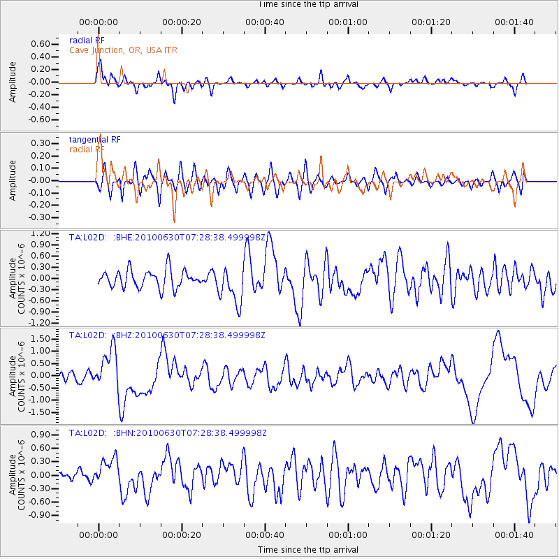
L02D Cave Junction, OR, USA - Earthquake Result Viewer
*The percent match for this event was below the threshold and hence no stack was calculated.
| Earthquake location: |
Oaxaca, Mexico |
| Earthquake latitude/longitude: |
16.4/-97.8 |
| Earthquake time(UTC): |
2010/06/30 (181) 07:22:27 GMT |
| Earthquake Depth: |
20 km |
| Earthquake Magnitude: |
5.9 MB, 6.0 MS, 6.2 MW, 6.3 MW |
| Earthquake Catalog/Contributor: |
WHDF/NEIC |
|
| Network: |
TA USArray Transportable Network (new EarthScope stations) |
| Station: |
L02D Cave Junction, OR, USA |
| Lat/Lon: |
42.16 N/123.60 W |
| Elevation: |
458 m |
|
| Distance: |
33.9 deg |
| Az: |
324.503 deg |
| Baz: |
131.446 deg |
| Ray Param: |
$rayparam |
*The percent match for this event was below the threshold and hence was not used in the summary stack. |
|
| Radial Match: |
77.53627 % |
| Radial Bump: |
400 |
| Transverse Match: |
68.42622 % |
| Transverse Bump: |
400 |
| SOD ConfigId: |
318645 |
| Insert Time: |
2010-11-29 20:50:08.657 +0000 |
| GWidth: |
2.5 |
| Max Bumps: |
400 |
| Tol: |
0.001 |
|
Signal To Noise
| Channel | StoN | STA | LTA |
| TA:L02D: :BHZ:20100630T07:28:38.499998Z | 2.8952649 | 8.541697E-7 | 2.9502297E-7 |
| TA:L02D: :BHN:20100630T07:28:38.499998Z | 2.4586575 | 3.1768056E-7 | 1.2920896E-7 |
| TA:L02D: :BHE:20100630T07:28:38.499998Z | 2.2056806 | 5.1597544E-7 | 2.3393024E-7 |
| Arrivals |
| Ps | |
| PpPs | |
| PsPs/PpSs | |


