You are here: Home > Network List > AV - Alaska Volcano Observatory Stations List
> Station N20K Mount Spurr, AK, USA > Earthquake Result Viewer
N20K Mount Spurr, AK, USA - Earthquake Result Viewer
| Earthquake location: |
Off Coast Of Central America |
| Earthquake latitude/longitude: |
12.7/-90.9 |
| Earthquake time(UTC): |
2023/07/30 (211) 01:10:29 GMT |
| Earthquake Depth: |
10 km |
| Earthquake Magnitude: |
5.7 Mww |
| Earthquake Catalog/Contributor: |
NEIC PDE/us |
|
| Network: |
AV Alaska Volcano Observatory |
| Station: |
N20K Mount Spurr, AK, USA |
| Lat/Lon: |
61.20 N/152.21 W |
| Elevation: |
991 m |
|
| Distance: |
65.3 deg |
| Az: |
332.109 deg |
| Baz: |
109.52 deg |
| Ray Param: |
0.05839132 |
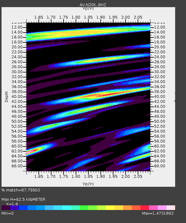
| Estimated Moho Depth: |
62.5 km |
| Estimated Crust Vp/Vs: |
1.60 |
| Assumed Crust Vp: |
6.566 km/s |
| Estimated Crust Vs: |
4.104 km/s |
| Estimated Crust Poisson's Ratio: |
0.18 |
|
| Radial Match: |
87.75503 % |
| Radial Bump: |
400 |
| Transverse Match: |
88.3008 % |
| Transverse Bump: |
400 |
| SOD ConfigId: |
31937991 |
| Insert Time: |
2023-08-13 01:20:28.337 +0000 |
| GWidth: |
2.5 |
| Max Bumps: |
400 |
| Tol: |
0.001 |
|

Signal To Noise
| Channel | StoN | STA | LTA |
| AV:N20K: :BHZ:20230730T01:20:40.27499Z | 11.368972 | 6.1642913E-7 | 5.422031E-8 |
| AV:N20K: :BHN:20230730T01:20:40.27499Z | 2.5527477 | 1.5049149E-7 | 5.8952747E-8 |
| AV:N20K: :BHE:20230730T01:20:40.27499Z | 4.146206 | 2.3846263E-7 | 5.7513454E-8 |
| Arrivals |
| Ps | 6.0 SECOND |
| PpPs | 24 SECOND |
| PsPs/PpSs | 30 SECOND |


