You are here: Home > Network List > IW - Intermountain West Stations List
> Station MOOW Moose Ponds, Wyoming, USA > Earthquake Result Viewer
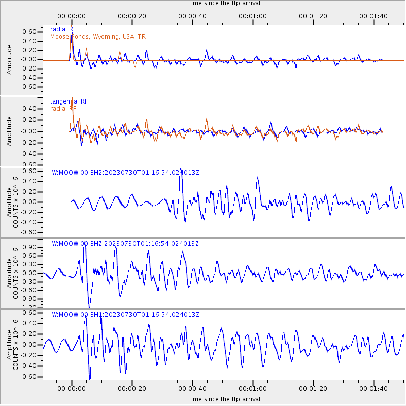
MOOW Moose Ponds, Wyoming, USA - Earthquake Result Viewer
*The percent match for this event was below the threshold and hence no stack was calculated.
| Earthquake location: |
Off Coast Of Central America |
| Earthquake latitude/longitude: |
12.7/-90.9 |
| Earthquake time(UTC): |
2023/07/30 (211) 01:10:29 GMT |
| Earthquake Depth: |
10 km |
| Earthquake Magnitude: |
5.7 Mww |
| Earthquake Catalog/Contributor: |
NEIC PDE/us |
|
| Network: |
IW Intermountain West |
| Station: |
MOOW Moose Ponds, Wyoming, USA |
| Lat/Lon: |
43.75 N/110.74 W |
| Elevation: |
2128 m |
|
| Distance: |
35.3 deg |
| Az: |
334.786 deg |
| Baz: |
145.003 deg |
| Ray Param: |
$rayparam |
*The percent match for this event was below the threshold and hence was not used in the summary stack. |
|
| Radial Match: |
79.28172 % |
| Radial Bump: |
400 |
| Transverse Match: |
72.56149 % |
| Transverse Bump: |
400 |
| SOD ConfigId: |
31937991 |
| Insert Time: |
2023-08-13 01:33:11.454 +0000 |
| GWidth: |
2.5 |
| Max Bumps: |
400 |
| Tol: |
0.001 |
|
Signal To Noise
| Channel | StoN | STA | LTA |
| IW:MOOW:00:BHZ:20230730T01:16:54.024013Z | 4.491749 | 4.3730702E-7 | 9.7357855E-8 |
| IW:MOOW:00:BH1:20230730T01:16:54.024013Z | 2.6838708 | 2.1635482E-7 | 8.061298E-8 |
| IW:MOOW:00:BH2:20230730T01:16:54.024013Z | 1.6301582 | 1.2565914E-7 | 7.708401E-8 |
| Arrivals |
| Ps | |
| PpPs | |
| PsPs/PpSs | |


