You are here: Home > Network List > UO - University of Oregon Regional Network Stations List
> Station LAIR Myrtle Point, OR, USA > Earthquake Result Viewer
LAIR Myrtle Point, OR, USA - Earthquake Result Viewer
| Earthquake location: |
Off Coast Of Central America |
| Earthquake latitude/longitude: |
12.7/-90.9 |
| Earthquake time(UTC): |
2023/07/30 (211) 01:10:29 GMT |
| Earthquake Depth: |
10 km |
| Earthquake Magnitude: |
5.7 Mww |
| Earthquake Catalog/Contributor: |
NEIC PDE/us |
|
| Network: |
UO University of Oregon Regional Network |
| Station: |
LAIR Myrtle Point, OR, USA |
| Lat/Lon: |
43.16 N/123.93 W |
| Elevation: |
128 m |
|
| Distance: |
41.6 deg |
| Az: |
323.054 deg |
| Baz: |
126.731 deg |
| Ray Param: |
0.07369206 |
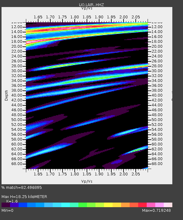
| Estimated Moho Depth: |
18.25 km |
| Estimated Crust Vp/Vs: |
1.60 |
| Assumed Crust Vp: |
6.522 km/s |
| Estimated Crust Vs: |
4.076 km/s |
| Estimated Crust Poisson's Ratio: |
0.18 |
|
| Radial Match: |
82.496895 % |
| Radial Bump: |
400 |
| Transverse Match: |
83.70451 % |
| Transverse Bump: |
400 |
| SOD ConfigId: |
31937991 |
| Insert Time: |
2023-08-13 01:40:03.205 +0000 |
| GWidth: |
2.5 |
| Max Bumps: |
400 |
| Tol: |
0.001 |
|

Signal To Noise
| Channel | StoN | STA | LTA |
| UO:LAIR: :HHZ:20230730T01:17:46.798Z | 12.536615 | 1.8045278E-6 | 1.4394058E-7 |
| UO:LAIR: :HHN:20230730T01:17:46.798Z | 3.4709575 | 3.359394E-7 | 9.6785804E-8 |
| UO:LAIR: :HHE:20230730T01:17:46.798Z | 2.7050607 | 4.687915E-7 | 1.7330166E-7 |
| Arrivals |
| Ps | 1.8 SECOND |
| PpPs | 6.7 SECOND |
| PsPs/PpSs | 8.5 SECOND |


