You are here: Home > Network List > UO - University of Oregon Regional Network Stations List
> Station RSBO Finn Rock, OR, USA > Earthquake Result Viewer
RSBO Finn Rock, OR, USA - Earthquake Result Viewer
| Earthquake location: |
Off Coast Of Central America |
| Earthquake latitude/longitude: |
12.7/-90.9 |
| Earthquake time(UTC): |
2023/07/30 (211) 01:10:29 GMT |
| Earthquake Depth: |
10 km |
| Earthquake Magnitude: |
5.7 Mww |
| Earthquake Catalog/Contributor: |
NEIC PDE/us |
|
| Network: |
UO University of Oregon Regional Network |
| Station: |
RSBO Finn Rock, OR, USA |
| Lat/Lon: |
44.04 N/122.27 W |
| Elevation: |
1235 m |
|
| Distance: |
41.2 deg |
| Az: |
325.232 deg |
| Baz: |
129.508 deg |
| Ray Param: |
0.073948205 |
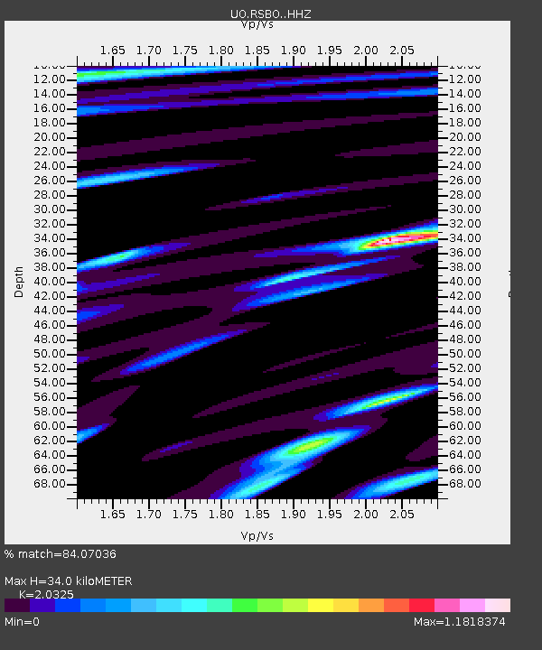
| Estimated Moho Depth: |
34.0 km |
| Estimated Crust Vp/Vs: |
2.03 |
| Assumed Crust Vp: |
6.566 km/s |
| Estimated Crust Vs: |
3.231 km/s |
| Estimated Crust Poisson's Ratio: |
0.34 |
|
| Radial Match: |
84.07036 % |
| Radial Bump: |
400 |
| Transverse Match: |
77.27492 % |
| Transverse Bump: |
400 |
| SOD ConfigId: |
31937991 |
| Insert Time: |
2023-08-13 01:40:31.005 +0000 |
| GWidth: |
2.5 |
| Max Bumps: |
400 |
| Tol: |
0.001 |
|

Signal To Noise
| Channel | StoN | STA | LTA |
| UO:RSBO: :HHZ:20230730T01:17:43.459987Z | 30.553423 | 1.4466708E-6 | 4.7348895E-8 |
| UO:RSBO: :HHN:20230730T01:17:43.459987Z | 4.8867645 | 5.502425E-7 | 1.1259852E-7 |
| UO:RSBO: :HHE:20230730T01:17:43.459987Z | 4.0995493 | 4.997733E-7 | 1.2190932E-7 |
| Arrivals |
| Ps | 5.7 SECOND |
| PpPs | 15 SECOND |
| PsPs/PpSs | 20 SECOND |


