You are here: Home > Network List > UW - Pacific Northwest Regional Seismic Network Stations List
> Station BDGR Fisse-Smith Property, Kittitas, WA, USA > Earthquake Result Viewer
BDGR Fisse-Smith Property, Kittitas, WA, USA - Earthquake Result Viewer
| Earthquake location: |
Off Coast Of Central America |
| Earthquake latitude/longitude: |
12.7/-90.9 |
| Earthquake time(UTC): |
2023/07/30 (211) 01:10:29 GMT |
| Earthquake Depth: |
10 km |
| Earthquake Magnitude: |
5.7 Mww |
| Earthquake Catalog/Contributor: |
NEIC PDE/us |
|
| Network: |
UW Pacific Northwest Regional Seismic Network |
| Station: |
BDGR Fisse-Smith Property, Kittitas, WA, USA |
| Lat/Lon: |
46.86 N/120.30 W |
| Elevation: |
642 m |
|
| Distance: |
42.0 deg |
| Az: |
329.781 deg |
| Baz: |
134.309 deg |
| Ray Param: |
0.07341018 |
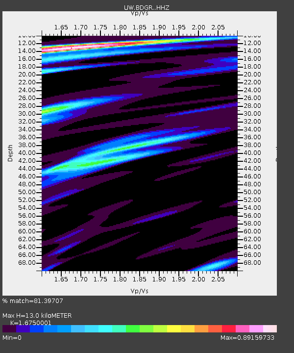
| Estimated Moho Depth: |
13.0 km |
| Estimated Crust Vp/Vs: |
1.68 |
| Assumed Crust Vp: |
6.597 km/s |
| Estimated Crust Vs: |
3.939 km/s |
| Estimated Crust Poisson's Ratio: |
0.22 |
|
| Radial Match: |
81.39707 % |
| Radial Bump: |
282 |
| Transverse Match: |
80.75753 % |
| Transverse Bump: |
385 |
| SOD ConfigId: |
31937991 |
| Insert Time: |
2023-08-13 01:42:39.018 +0000 |
| GWidth: |
2.5 |
| Max Bumps: |
400 |
| Tol: |
0.001 |
|

Signal To Noise
| Channel | StoN | STA | LTA |
| UW:BDGR: :HHZ:20230730T01:17:50.39999Z | 8.029679 | 8.827414E-7 | 1.0993483E-7 |
| UW:BDGR: :HHN:20230730T01:17:50.39999Z | 2.2615614 | 3.0474504E-7 | 1.3474984E-7 |
| UW:BDGR: :HHE:20230730T01:17:50.39999Z | 3.306525 | 2.980278E-7 | 9.013324E-8 |
| Arrivals |
| Ps | 1.4 SECOND |
| PpPs | 4.9 SECOND |
| PsPs/PpSs | 6.3 SECOND |


