You are here: Home > Network List > UW - Pacific Northwest Regional Seismic Network Stations List
> Station UMAT Pilot Rock, OR, USA > Earthquake Result Viewer
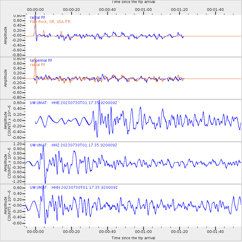
UMAT Pilot Rock, OR, USA - Earthquake Result Viewer
*The percent match for this event was below the threshold and hence no stack was calculated.
| Earthquake location: |
Off Coast Of Central America |
| Earthquake latitude/longitude: |
12.7/-90.9 |
| Earthquake time(UTC): |
2023/07/30 (211) 01:10:29 GMT |
| Earthquake Depth: |
10 km |
| Earthquake Magnitude: |
5.7 Mww |
| Earthquake Catalog/Contributor: |
NEIC PDE/us |
|
| Network: |
UW Pacific Northwest Regional Seismic Network |
| Station: |
UMAT Pilot Rock, OR, USA |
| Lat/Lon: |
45.29 N/118.96 W |
| Elevation: |
1318 m |
|
| Distance: |
40.3 deg |
| Az: |
329.075 deg |
| Baz: |
134.738 deg |
| Ray Param: |
$rayparam |
*The percent match for this event was below the threshold and hence was not used in the summary stack. |
|
| Radial Match: |
70.90804 % |
| Radial Bump: |
289 |
| Transverse Match: |
64.40888 % |
| Transverse Bump: |
400 |
| SOD ConfigId: |
31937991 |
| Insert Time: |
2023-08-13 01:45:59.017 +0000 |
| GWidth: |
2.5 |
| Max Bumps: |
400 |
| Tol: |
0.001 |
|
Signal To Noise
| Channel | StoN | STA | LTA |
| UW:UMAT: :HHZ:20230730T01:17:35.920009Z | 6.4768596 | 4.2595835E-7 | 6.576619E-8 |
| UW:UMAT: :HHN:20230730T01:17:35.920009Z | 6.242019 | 2.9301054E-7 | 4.694163E-8 |
| UW:UMAT: :HHE:20230730T01:17:35.920009Z | 2.5329974 | 2.2551676E-7 | 8.903158E-8 |
| Arrivals |
| Ps | |
| PpPs | |
| PsPs/PpSs | |


